
Klus (Balsthal)
| Klus | |
|---|---|
| State : |
|
| Canton : |
|
| District : | Thal |
| Residential municipality : | Balsthal |
| Postal code : | 4710 |
| former BFS no. : | 2422 |
| UN / LOCODE : | CH BST |
| Coordinates : | 619 834 / 238812 |
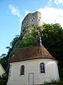
 Town of Klus with Alt-Falkenstein Castle |
|
| map | |
 |
|
Klus is a village in the canton of Solothurn , which belongs to the municipality of Balsthal . The village lies in the Klus von Oensingen -Balsthal on the Dünnern . It was first mentioned in a document in 1308 under the name Clusen .
history

In the Middle Ages the dingstatt Innert dem Rossnagel des Buchsgau was located in the Klus with a regional court that was active until 1513. The walled town was founded by the Counts of Falkenstein around 1240/1250 in order to be able to block the northern exit of the Klus. Despite customs and market rights, it never had more than 16 farms with around 100 inhabitants. The town was destroyed by the Guglers in 1375 . In 1420 Klus fell to the city of Solothurn with the rule of Alt-Falkenstein and was assigned to the municipality of Balsthal. In 1632, during the Thirty Years' War , there was a clash, the Kluser Handel , between Solothurn and Bernese troops, which threatened to degenerate into a federal civil war. The first own school was established in 1860. The former town charter was retained as the Klus corporation (today: Bürgergemeinde Balsthal ) with its own citizenship and forest.
economy
The economic beginnings began in the middle of the 15th century with the St. Agatha glass fraternity with 21 masters, a hammer forge and iron smelting for smelting the ore in the valley.
From the end of the 15th to the middle of the 19th century, Klus counted around a quarter of the inhabitants of Balsthal and provided one of the four guards to the village watch and fire department. From the 16th century, the Klus benefited from pass traffic.
The great economic boom began in 1813 with the construction of a blast furnace by Solothurn councilor Ludwig von Roll . A foundry was attached to the blast furnace in 1827 , which employed 900 workers in 1900 and 1230 in 1913. The entire valley floor was built with factory buildings and workers' houses.
Attractions
The Alt-Falkenstein Castle , built around 1100, is located at the narrowest point of the gorge above the town. The Joseph Chapel was donated in 1760.
The view from the Schwängimatt shows the Folded Jura and the western plateau. The origins of the Jura Mountains come to light in the Klus, the folding layers are exposed.
Joseph's Chapel from 1760

Former archive of the community of Balsthal

Klus train station and the smelter administration building


literature
- Hans Sigrist: Balsthal. 3000 years of village history. In: Yearbook for Solothurn History. Volume 41, 1968, pp. 5-352 ( doi : 10.5169 / seals-324386 )
Web links
- Hans Sigrist: Klus. In: Historical Lexicon of Switzerland .
Individual evidence
- ↑ so.ch: Canton of Solothurn: Schwängimatt - der Jurafalter ( Memento of the original from October 13, 2011 in the Internet Archive ) Info: The archive link was inserted automatically and has not yet been checked. Please check the original and archive link according to the instructions and then remove this notice. , Accessed May 6, 2011