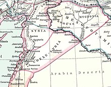
Koile Syria
An ancient landscape is referred to as Koilesyria ( Greek : Κοίλη Συρία; Latin Coele Syria , also Syria Coele , of which earlier in German also Kölesyrien or Cölesyrien ). The Greek name means "hollow Syria" and is perhaps a corruption of the Semitic kol surija ("all of Syria").
The geographical area to which the name Koile Syria referred was not clearly established. It could be used to describe the landscape between Lebanon and Anti-Lebanon , through which the Orontes flows (today the Bekaa plain ). Since the Diadoch period (323 BC) the name Koilesyria was extended to the whole of southern Syria, partly including Palestine and Phenicia , which was long disputed between Ptolemies and Seleucids . The province of Koilesyria went to the Seleucids in the course of the Maccabees uprising from 165 BC. Chr. Gradually lost. The Judean Kingdom of the Hasmoneans was formed on their territory .
Under the Roman emperor Septimius Severus , a province of Syria Coele was established in 194 AD , which comprised the northern part of the previous province of Syria Palestine .
Hellenistic governor of Koile Syria
- Theodotos, son of Antibolus ; (officiated under Ptolemy IV since 221 BC, defected to Antiochus III in 219 BC)
- Andromachos ; (used by Ptolemy IV after the Battle of Raphia in 217 BC)
- Threaseas son of Aetos ; (officiated under Ptolemy IV from 217 to 204 BC at the latest)
- Ptolemy son of Thraseas ; (officiated at the latest from 204 BC under Ptolemy V, went over to the Seleucids in 202 BC)
- Apollonios son of Thraseas ; (officiated under Seleucus IV.)
- Apollonios, son of Menestheos ; (served under Seleucus IV and Antiochus IV until shortly after 170 BC)
- Ptolemy, son of Dorymenes ; (officiated under Antiochus IV and was deposed in 165 BC)
- Ptolemy Macron ; (163 committed v. Chr. suicide )
literature
- Georg Beer : Koile Syria . In: Paulys Realencyclopadie der classischen Antiquity Science (RE). Volume XI, 1, Stuttgart 1921, Sp. 1050-1052.
- Othmar Keel , Max Küchler , Christoph Uehlinger: Places and landscapes of the Bible . A handbook and study guide to the Holy Land. tape 1 : Geographical and historical regional studies. Vandenhoeck & Ruprecht, Göttingen 1984, ISBN 3-525-50166-8 , "Syrien" and "Koilesyrien", pp. 237 ff . ( Online [accessed January 22, 2012]).
