Kolka
| Kolka | ||
|---|---|---|
 Help on coat of arms |
|
|
| Basic data | ||
| State : |
|
|
| Landscape: | Courland ( Latvian : Kurzeme ) | |
| Administrative district : | Dundagas novads | |
| Coordinates : | 57 ° 45 ' N , 22 ° 36' E | |
| Residents : | 765 | |
| Area : | ||
| Population density : | ||
| Height : | 3 m | |
| Website: | www.kolka.lv | |
| Post Code: | ||
| ISO code: | ||
| Church in Kolka | ||

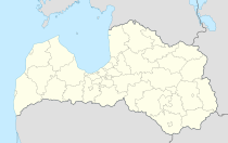
Kolka ( Liv : Kūolka , German:, potholes') is a fishing village in the west of Latvia and nördlichster point of the region Kurland .
The village lies on the prominent headland Kolkas rags (Horn of Kolka ', Kolkasrags' Cape Domesnäs ) of Irben Straits , the at the Baltic Sea and the Gulf of Riga meeting.
The last representatives of the Liv language and culture live in Kolka today . The area lies within the Slītere National Park .
history
Between 1384 and 1387 Kolka is first mentioned in written sources as an inhabited place. The inhabitants lived from fishing and robbing the ships that were stranded on the Cape.
administration
In the municipality are the places Kolka, Vaide, Saunags, Pitrags, Košrags, Mazirbe and Sīkrags. Since 2009 the community has belonged to Dundagas novads . (See also: Administrative division of Latvia .)
literature
- Hans Feldmann , Heinz von zur Mühlen (Hrsg.): Baltic historical local dictionary, part 2: Latvia (southern Livland and Courland). Böhlau, Cologne 1990, ISBN 3-412-06889-6 , p. 294.
- Astrīda Iltnere (ed.): Latvijas Pagasti, Enciklopēdija. Preses Nams, Riga 2002, ISBN 9984-00-436-8 .

