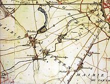
Kriel (municipality)
Until 1888, Kriel was a municipality in the Cologne district in the Prussian Rhine province . The former municipal area essentially comprised today's Cologne districts of Braunsfeld , Lindenthal and Sülz .
history

In the 19th century Kriel belonged to the municipalities of Efferen and Stotzheim to the mayor's office in Efferen in the district of Cologne. The municipality Kriel next to the eponymous church town belonged Kriel also the places Brown field, Lind and Suelz and residential places capstone, Falkenburg, Kitschburg , Lindeburg and Neuenhof.
In 1846, the Lindenthal residential colony was established in Kriel's municipality . Thanks to its proximity to Cologne city center, just a few years after it was founded, it already had significantly more residents than the core town of Kriel. Sülz, with its more industrial character, developed into a further population center of the community.
The office building of the mayor's office in Efferen was relocated to Falkenburg on the corner of Krieler Strasse and Falkenburgstrasse in 1864. In the last census before incorporation in 1885, the following population figures were found:
| Lindenthal | 2,758 |
| Sülz | 2,495 |
| Braunsfeld | 643 |
| Lind | 356 |
| Lindenburg | 206 |
| Kriel | 126 |
| Capstone | 37 |
| Neuenhof | 19th |
| Kitsch castle | 5 |
| Falkenburg | 4th |
| Municipality of Kriel | 6,649 |
The entire municipality of Kriel was incorporated into the city of Cologne on April 1, 1888, along with other Cologne suburbs.
The place name Kriel is no longer used in everyday life for a district, but lives on in the vernacular as Krieler Veedel as well as in the name of Krieler Straße and the name Krieler Dömchen . A local branch of Sparkasse KölnBonn also operates under the name Filiale Kriel .
The former municipality of Kriel also forms the official district Kriel within the city of Cologne, for which a separate land register is kept.
Individual evidence
- ^ Community encyclopedia for the Rhineland Province (PDF; 1.3 MB), Berlin: Verlag des Königlichen Statistischen Bureaus, 1888, page 124 ff
Coordinates: 50 ° 55 ′ 37 ″ N , 6 ° 54 ′ 27 ″ E