Kronskark
| Kronskark Want 10 | ||
|---|---|---|
|
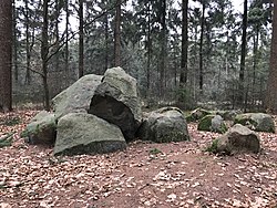
Main and side stones of the grave complex |
||
|
|
||
| Coordinates | 53 ° 42 '21.4 " N , 8 ° 48' 1.9" E | |
| place | Wanna , Lower Saxony , Germany | |
| Emergence | 3500 to 2800 BC Chr. | |
Kronskark (also called Wanna 10) is a megalithic complex in the "Am hoch Kopf" forest in the Ahlen-Falkenberg district near Wanna in the Cuxhaven district in the Elbe-Weser triangle .
description
Two end stones and four lateral bearing stones each show the former dimensions of this severely disturbed chamber of 6 m × 1.8 meters. Of the three capstones in the western part of the chamber, two that are almost vertical fell into the chamber. A gap in the chamber wall on the south side may indicate the location of the old entrance to the passage grave .
The pastor J. J. Plate from Wanna prevented the complete destruction of the complex in 1748. There is a drawing of Otto Kaule's (1870–1948) grave from 1907. There are other stone monuments in the area. A destroyed stone chamber was examined a little south of the Kronskark in 1963 because it was endangered by sand mining. A reconstruction of a stone grave was built from their stones in the courtyard of the elementary school in Wanna.
See also
literature
- Announcements of the Marschenrat to promote research in the coastal area of the North Sea 3. Wilhelmshaven 1963, p. 27f.
- Ernst Sprockhoff : Atlas of the megalithic tombs of Germany. Part 3: Lower Saxony - Westphalia. Rudolf-Habelt Verlag, Bonn 1975, ISBN 3-7749-1326-9 , pp. 13-15.

