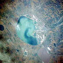
Kulunda lake
| Kulunda lake | ||
|---|---|---|

|
||
| Lake Kulunda from the north | ||
| Geographical location | West Siberian Lowlands ( Kulunda Steppe ) | |
| Tributaries | Kulunda , Sujetka | |
| Drain | drainless | |
| Location close to the shore | Blagoveshchenka | |
| Data | ||
| Coordinates | 53 ° 0 ′ N , 79 ° 30 ′ E | |
|
|
||
| Altitude above sea level | 98 m | |
| surface | 728 km² | |
| length | 35 km | |
| width | 25 km | |
| Maximum depth | 4 m | |
|
particularities |
Salt lake ( sodium sulfate ) |
|
The Lake Kulundinskoye ( Russian Кулундинское озеро / Kulundinskoje Ozero) is a salt lake in the southeast of the West Siberian lowlands ( Altai Krai , Russia , Asia ).
It lies in a basin without any drainage in the Kulunda steppe and is 728 km² in size. The level of the Kulunda lake is 98 m high, with a maximum water depth of only 4 meters. The north-south extension is about 35 kilometers, the west-east 25 kilometers. The north and west banks are steep, while the east bank is flat and swampy.
The only notable tributaries, the Kulunda and Sujetka , also flow into the lake from the east . In addition, a number of rich artesian springs come to light in the vicinity of the lake . In the south, the lake has a narrow connection to the somewhat lower, 6 kilometers away Kutschuksee ( Кучукское озеро / Kutschukskoje osero).
Because of its salt content ( sodium sulphate ), the lake does not freeze in winter.
To the south-east of the lake are the urban-type settlements of Blagoveshchenka (administrative center of the raion of the same name , with Novoblagoveshchenka railway station on the Barnaul - Kulunda - Pavlodar railway line south of the lake ) and Stepnoye Osero . The non-saline areas around Lake Kulunda are used intensively for agriculture.
Web links
Individual evidence
- ↑ Article Kulundasee in the Great Soviet Encyclopedia (BSE) , 3rd edition 1969–1978 (Russian)
- ↑ Russian topographic map 1: 200,000 N-44-26 (1993)

