Kurogi (Fukuoka)
| Kurogi-machi 黒 木 町 |
||
|---|---|---|
|
|
||
| Geographical location in Japan | ||
| Region : | Kyushu | |
| Prefecture : | Fukuoka | |
| Coordinates : | 33 ° 13 ' N , 130 ° 40' E | |
| Basic data | ||
| Surface: | 135.49 km² | |
| Residents : | ||
| Community key : | 40541-8 | |
| Symbols | ||
| Tree : | Camphor tree | |
| Flower : | Japanese wisteria | |
| town hall | ||
| Address : |
Kurogi Town Hall 1314 - 1 , OÁZA Ima Kurogi -machi, Yame-gun Fukuoka 834-1292 |
|
| Website URL: | http://www.town.kurogi.fukuoka.jp | |
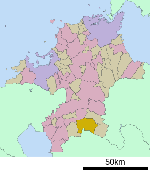
| Location Kurogis in Fukuoka Prefecture | ||
Kurogi ( Japanese 黒 木 町 , - machi ) was a city in Yame-gun in the Japanese prefecture of Fukuoka . On February 1, 2010, she joined Hoshino , Tachibana, and Yabe to form the Yame Ward .
history
Kurogi originally belonged to the Shimotsuma-gun , which merged with parts of the Ikuha-gun to form the Yame-gun on February 26, 1896 .
On April 1, 1954, four Mura ( 笠原村 (Kasahara-mura) 木屋村 (Kiya-mura) 串毛村 (Kushige-mura) and 豊岡村 (Toyooka-mura)) and on 31 March 1957, a further Mura ( 大 淵 村 , Ōbuchi-mura), each from the Yame-gun, incorporated.

