
Lac de Nino
| Lac de Nino | ||
|---|---|---|

|
||
| Lac de Nino | ||
| Geographical location | Haute-Corse , Corsica , France | |
| Tributaries | Tavignano | |
| Drain | Tavignano | |
| Data | ||
| Coordinates | 42 ° 15 '20 " N , 8 ° 56' 25" E | |
|
||
| Altitude above sea level | 1743 m | |
| surface | 6.5 ha | |
| length | 425 m | |
| width | 250 m | |
| Maximum depth | 12 m | |

The Lac de Nino (Corsican Lavu di Ninu ) is a lake in Corsica in the Corsica Regional Nature Park ( Haute-Corse department ) in the municipality of Corte . With the north bank it borders on the municipality of Casamaccioli . It is located on the high plateau du Camputile on the GR 20 long-distance hiking trail . It can be reached on foot in just under two hours from the D 84 state road. The starting point is the forester's house Popaghja at an altitude of 1120 m , which is halfway between the Niolu villages and the pass over the Col de Vergio .
geography
The mountain lake at 1743 m above sea level has an area of 6.5 ha and a maximum depth of 11 m. It is frozen over five to six months a year and forms the spring collecting basin of the river Tavignano .
The Lac de Nino is of glacial origin and surrounded by ancient moraines . A fen with meandering meltwater inflows surrounds the northern part of the lake. There are spawning herbs and fever clover plants .

Start of the hiking trail to Lac de Nino

Lake seen from the northwest ridge with horses grazing in the foreground

Lake seen from the southeast

Information sign about the lake near Lac de Nino
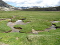
Meltwater inflows meander to the lake.


literature
- Julia Kühling, Karen Nölle-Fischer: MARCO POLO travel guide Corsica: Travel with insider tips. With travel atlas and French phrase book . 11th updated edition. MAIRDUMONT, Ostfildern 2008, ISBN 978-3-8297-0460-1 .