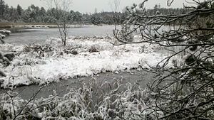
Laughing pond
| Laughing pond | ||
|---|---|---|

|
||
| Laughing pond | ||
| Geographical location | Bavaria , Germany | |
| Drain | Nussberger Weiher → Seeseitenbach → Starnberger See → Würm → Amper → Isar → Danube → Black Sea | |
| Location close to the shore | Seeshaupt | |
| Data | ||
| Coordinates | 47 ° 50 '54.7 " N , 11 ° 15' 16.9" E | |
|
|
||
| Altitude above sea level | 638 m | |
| surface | 0.63 ha | |
| length | approx. 100 m | |
| width | approx. 80 m | |
The Lachenweiher or Schwarze Lache is a moor lake in the Bernrieder Filz nature reserve in the north-western municipality of Seeshaupt , in the Magnetsried district . It drains through numerous ditches to the Nussberger Weiher . You can approach the pond from the hamlet of Nussberg . It cannot be reached directly due to the large areas of rewetting of the moor.
Individual evidence
- ↑ http://geoportal.bayern.de/bayernatlas/?X=5300918.83&Y=4445808.14&zoom=10&lang=de&topic=ba&bgLayer=tk&catalogNodes=122 Bayernatlas
- ↑ http://www.weilheim-schongau.bund-naturschutz.de/projekte/bernrieder-filz.html
