Laganas
|
Laganas parish Δημοτική Ενότητα Λαγανά (Λαγανάς) |
||
|---|---|---|
|
|
||
| Basic data | ||
| State : |
|
|
| Region : |
Ionian islands
|
|
| Regional District : | Zakynthos | |
| Municipality : | Zakynthos | |
| Geographic coordinates : | 37 ° 42 ′ N , 20 ° 50 ′ E | |
| Height above d. M .: | 0 - 416 m sea - Kakavitsa |
|
| Area : | 73.804 km² | |
| Residents : | 6,986 (2011) | |
| Population density : | 94.7 inhabitants / km² | |
| Code No .: | 330106 | |
| Structure: |
3 city districts 3 local communities |
|
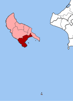
| Location in Zakynthos Municipality and Zakynthos Regional Unit | ||
Laganas ( Greek Λαγανάς ( m. Sg. )) Was a municipality (officially Dimos Lagana Δήμος Λαγανά) on the Greek island and prefecture of Zakynthos from 1997 to 2010 .
The municipality comprised the south-west and south of the island of Zakynthos. The area includes the Marathia Peninsula, the uninhabited island of Marathonisi in the bay of Laganas and the small rocky island of Agios Sostis. To the east, the area of the municipality extends to the northern border of the Skopos peninsula and includes the west and north coast of the Bay of Laganas. The landscape of the municipality is designed differently according to its extent. The eastern part around the villages of Kalamaki and Laganas consists of the fertile plain of Zakynthos, which is separated from the sea (Bay of Laganas) by an extensive sandy beach with a length of approx. 7 km. The middle part of the area is determined by the hilly landscape east of the Zakynthian ridge: it is used intensively for agriculture, especially for the cultivation of olive trees. The largest village of Pandokratora is located in this hilly landscape. The west is dominated by the mountain range of Zakynthos, which runs south into the Marathia peninsula. Extensive cliffs with a height of up to 200 m can be found here, especially on the west coast of the Ionian Sea. The highest elevation of the municipality, the Kakavitsa with 416 m height, is on the Marathia Peninsula, as well as the second highest elevation, the Skopos with 413 m. In the transition between the western and central municipality there is a lake at a natural harbor in the village of Keri, the Keri Lake (Limni Keriou). This has been known for its sources of bad luck since ancient times . The southernmost point of the island of Zakynthos, Cape Marathias on the peninsula of the same name, is also located in the municipality of Laganas.
Economically, agriculture and tourism are the main fields of activity for the residents of Laganas. The small town of Laganas in particular is populated by tourists with a multiple of its population during the travel season.
Administrative division
The municipality of Laganas was founded from six rural municipalities in the course of the municipality reform in 1997 . The administrative seat was Pandokratoras. With the administrative reform in 2010 , the six municipalities of the island of Zakynthos were merged, the former municipalities have since had the status of municipal districts. The municipality of Laganas is divided into 3 city districts and 3 local communities.
| City district / local community |
Greek name | code | Area (km²) | 2001 residents | Residents 2011 | Villages and settlements |
|---|---|---|---|---|---|---|
| Lithakia | Δημοτική Κοινότητα Λιθακιάς | 33010605 | 12,166 | 1,185 | 1307 | Lithakia |
| Mouzaki | Δημοτική Κοινότητα Μουζακίου | 33010606 | 7.703 | 1352 | 1702 | Mouzaki |
| Pandokratoras | Δημοτική Κοινότητα Παντοκράτορος | 33010601 | 6,978 | 1442 | 1654 | Pandokratoras, Laganas |
| Agalas | Τοπική Κοινότητα Αγαλά | 33010602 | 22.013 | 334 | 342 | Agalas, Ai Giannis, Ambelos, Stimies |
| Kalamaki | Τοπική Κοινότητα Καλαμακίου | 33010603 | 8,000 | 901 | 1193 | Kalamaki, Margareika, Pefkakia |
| Keri | Τοπική Κοινότητα Κερίου | 33010604 | 17.244 | 680 | 788 | Keri, Apelati, Limni Keriou, Marathia |
| total | 330106 | 74.104 | 5,894 | 6986 | ||
literature
- Zakynthos. Road-Tourist & Navy Map, 1: 50,000. Orama Editions, Athens, ISBN 978-960-8283-05-3 .
- Zakynthos. Map of Greece 1: 60,000. Road Editions, Athens, ISBN 960-8481-53-8 .
- Marco Polo Greece - Mainland, Cyclades, Corfus, Sporades. Map 1: 300,000. Mairdumont, Ostfildern 2008, ISBN 978-3-8297-3750-0 .
- Klaus Bötig : Zákynthos (Itháki, Kefalloniá, Léfkas). 8th edition. Mairs Geographischer Verlag, Ostfildern 2005, ISBN 978-3-89525-753-7 .
- Anette Schwab, Günther Schwab: Zakynthos. 3. Edition. Müller, Erlangen 2007. ISBN 978-3-89953-344-6 .
- Stelios Kontaratos, Iakovos Kontarakos (ed.): Zakynthos. Summer Dream Editions, Athens, ISBN 960-7439-59-7 .
- Zakynthos. Adam Editions. Peania Attikis, ISBN 960-500-387-2 .
Individual evidence
- ↑ Results of the 2011 census at the National Statistical Service of Greece (ΕΛ.ΣΤΑΤ) ( Memento from June 27, 2015 in the Internet Archive ) (Excel document, 2.6 MB)
- ↑ Law 2539/1997, «Συγκρότηση της Πρωτοβάθμιας Τοπικής Αυτοδιοίκησης." ΦΕΚ 244A / December 4, 1997, Άρθρο 1. Σύσταση δήμων και κοινοτήτων. P. 8801. PDF Online (Greek)
- ↑ Kallikratis Program, Law 3852/2010, «Νέα Αρχιτεκτονική της Αυτοδιοίκησης και της Αποκεντρωμένης ΔιοκεντρωμΠνης Διοίκησης - Πρόγραμημα άρτάτης τρτάτης. ΦΕΚ 87 A / 7.6.2010, Άρθρο 1. Σύσταση δήμων. P. 1788. PDF Online (Greek)

