Lago Yanawayin
|
Lago Yanawayin Yanahuni, Yanahuin, Yanahuani, Laguna Pampa |
||
|---|---|---|

|
||
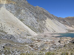
| Lake Yanahuin with remains of the Chungar Mine , destroyed by a tidal wave in 1971 | ||
| Geographical location |
|
|
| Drain | → Río Chicrin → Río Chancay | |
| Data | ||
| Coordinates | 11 ° 7 ′ 36 ″ S , 76 ° 32 ′ 7 ″ W | |
|
|
||
| Altitude above sea level | 4354 m | |
| surface | 8 ha | |
| length | 400 m | |
| width | 300 m | |
| scope | 1.40 km | |
Lago Yanawayin (or Yanahuni , Yanahuin or Yanahuani , also: Laguna Pampa ) is a 4354 m high mountain lake about eight hectares in the Peruvian Western Cordillera . The lake is located in the Santa Cruz de Andamarca district of the Huaral province in the Lima region . The name of the lake is made up of yana (black) and wayi (house / building) in Quechua .
The lake made headlines around the world in 1971 when, on March 18, a huge tidal wave caused by a rock fall razed the Chungar mine settlement on the shore and (according to various estimates) killed 200–600 people. The rock fall had loosened from the limestone 400 m above the lake level and comprised an estimated 100,000 m³ of rock. It triggered a tidal wave up to 30 m high, which buried the opposite bank under itself and destroyed almost the entire mine settlement. Some of the water poured into one of the mining shafts, where some of the miners were drowned to death.
literature
Eds. Stephen G. Evans, Jerome V. DeGraff, Catastrophic Landslides: Effects, Occurrence and Mechanisms (2002) in: Reviews in Engineering Geology Volume XV
Web links
- Dr. Hermann Fritz: Landslide Tsunami Experiments August 31, 2007 (PDF) ( English )
- MODELACIÓN CFD DE ONDAS TSUNAMI EN RESERVORIOS, LAGOS Y MINAS CAUSADAS POR DESLIZAMIENTOS DE LADERAS (2016) (PDF) ( Spanish )
