
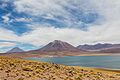
Laguna Miscanti
| Laguna Miscanti | ||
|---|---|---|
_03.jpg)
|
||
| Geographical location |
|
|
| Location close to the shore | San Pedro de Atacama | |
| Data | ||
| Coordinates | 23 ° 44 ′ 0 ″ S , 67 ° 46 ′ 0 ″ W | |
|
||
| Altitude above sea level | 4140 m | |
| surface | 13.5 km² | |
| Maximum depth | 10 m | |
| PH value | 8.8 | |
| Catchment area | 267.7 km² | |
|
particularities |
Salinity 5 g / l |
|

Laguna Miscanti is a salt lake in the Andes in northern Chile .
description
The Laguna Miscanti belongs to the municipality of San Pedro de Atacama in the Región de Antofagasta in the north of Chile . The lake lies at an altitude of 4140 m in the puna of the Andes at the foot of the Miscanti volcano (5622 m). It is located in the depression of a drainless water catchment area. It gets its water mainly from groundwater inflows from the surrounding mountains. Part of the water seeps into the nearby Laguna Miñiques.
As an important biotope, the lake is part of the Los Flamencos National Reserve . Flamingos and the rare species of duck Tagua Cornuda nest on its banks . Because of its scenic beauty, it is a destination for many thousands of tourists every year.
Sediment studies showed that a paleo lake formed there 22,000 years ago. This dried up under the extremely dry conditions of the last glacial maximum 18,000 years ago. A glacial lake formed 12,000 to 8,000 years ago. The climate was much more humid than today and a relatively dense vegetation could develop in the area. In the Middle Holocene , the climate was mostly extremely dry. Until about 3,600 years ago the lake was shallow and hypersaline and dried up several times. The current conditions have prevailed for about 3000 years.
The crater of the Miscanti volcano is about 6 km away from the lake.
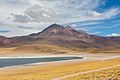
Meñiques volcano. Left the Laguna Miscanti. The white stripe on the right belongs to the shore of the neighboring Laguna Meñiques


.

Web links
- List of saline water bodies in the English language Wikipedia.
Individual evidence
- ↑ a b c GROSJEAN, M., et al. A 22,000 14 C year BP sediment and pollen record of climate change from Laguna Miscanti (23 ° S), northern Chile. Global and Planetary Change, 2001, Vol. 28, No. 1, pp. 35-51. Abstract
- ↑ a b VALERO-GARCÉS, Blas L., et al. Holocene lacustrine deposition in the Atacama Altiplano: facies models, climate and tectonic forcing (PDF; 2.7 MB). Palaeogeography, Palaeoclimatology, Palaeoecology, 1999, vol. 151, No. 1, pp. 101-125.
- ↑ Constanza Marcela Jiménez Riveros: Estudio de cuencas altiplánicas endorreicas de la Segunda Región de Chile . Caracterización, tipología y potencialidades de uso. In: Memoria para optar al Título de Geógrafo . Universidad de Chile. Facultad de Arquitectura y Urbanismo. Escuela de Geografía, Santiago de Chile 2012 (Spanish, online [PDF; accessed April 27, 2013]). ( Page no longer available , search in web archives ) Info: The link was automatically marked as defective. Please check the link according to the instructions and then remove this notice.
- ↑ CONTRERAS, Juan Pablo. North of Chile: Conservación de humedales altoandinos para un desarrollo productivo sustentable ( Memento of the original from March 27, 2016 in the Internet Archive ) Info: The archive link was inserted automatically and has not yet been checked. Please check the original and archive link according to the instructions and then remove this notice. (PDF; 56 kB). Ambiente y Desarrollo (Chile), 2002, 18th vol., Pp. 125-131.
- ↑ GROSJEAN, Martín, et al. From proxy data to paleoclimate interpretation: the mid-Holocene paradox of the Atacama Desert, northern Chile. Palaeogeography, Palaeoclimatology, Palaeoecology, 2003, Volume 194, No. 1, pp. 247-258. Abstract