
Lahinja
| Lahinja | ||
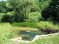
 Reka Lahinja at Primostek |
||
| Data | ||
| location | Bela krajina ( Slovenia ) | |
| River system | Danube | |
| Drain over | Kolpa → Save → Danube → Black Sea | |
| muzzle | at Primostek in the Kolpa coordinates: 45 ° 37 '43 " N , 15 ° 18' 3" E 45 ° 37 '43 " N , 15 ° 18' 3" E
|
|
| length | 33.4 km | |
| Small towns | Črnomelj | |
| Communities | Črnomelj, Metlika | |
| Residents in the catchment area | approx. 10000 | |
| Ports | 0 | |
| Navigable | No | |
The Lahinja is a 33.4 kilometer long river that lies entirely in the Bela krajina region of Slovenia. The sources of the Lahinja and the first seven kilometers of the river at Belčji vrh belong to the nature reserve Krajinski park Lahinja .
Tributaries
In the village of Mali Nerajc, the Nerajčica brook is the first major tributary to flow into the Lahinja. It has a minimum flow rate of approx. 20 l / s, which is surprisingly similar to the flow rate of the Lahinja itself.
At the village Dragatuš the slightly larger stream flows Podturnščica added, in the town of Črnomelj river Dobličica . The river bed is up to 20 m deep. The river meanders strongly. One of the most beautiful river bends is in Gradac. The Krupa River flows into the village of Klošter behind Gradac . The Lahinja joins the Kolpa near Primostek .
Water quality
Until about 30 years ago, the boiled water was used as drinking water because there was no drinking water supply in many Bela krajina villages. For example, the village of Gradac was only connected to the drinking water network in 1974.
Since dirty water and waste were discharged into the Lahinja without being treated, the water quality was correspondingly poor. Since the construction of the sewage treatment plant in Čnomelj in 1994–1996, the water quality has improved. Nevertheless, many people still use the river today as they did in the past for waste disposal.
gallery
Source of the Lahinja at Beljčji vrh

Source of the Lahinja at Beljčji vrh
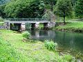
Lahinja near Butoraj - bridge
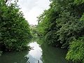
Lahinja near Črnomelj

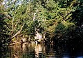
Lahinja at Gradac Castle
Lahinja near the village of Klošter

Lahinja at Pusti Gradac
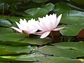
Water lilies on the Lahinja (Gradac Castle)

Pollution from bulky waste (old stove)

Plastic bottle in the Lahinja near Gradac
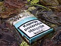
Pack of cigarettes in the Lahinja near Gradac


