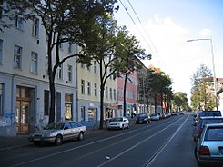
Langhansstrasse (Berlin)
| Langhansstrasse | |
|---|---|
| Street in Berlin | |
| Basic data | |
| place | Berlin |
| District | Weissensee |
| Created | in the 19th century |
| Hist. Names | Langhansstrasse, Traugottstrasse and Otzenstrasse |
| Cross streets | Heinersdorfer Strasse, Jacobsohnstrasse, Goethestrasse, Friesickestrasse, Rudolf-Baschant-Strasse (confluence), Goyastrasse (confluence), Roelckestrasse, Behaimstrasse, Börnestrasse, Berliner Allee |
| Places | Antonplatz |
| use | |
| User groups | Pedestrian traffic , bicycle traffic , car traffic , public transport |
| Technical specifications | |
| Street length | 1580 meters |
The Langhansstraße ( ) in Berlin-Weissensee that was created before the year 1874, 1878 experienced a union with Traugott road and Otzenstraße . It was previously limited to the part between Gustav-Adolf-Strasse and Roelckestrasse .
Origin of name
The street was named after the administrator of the Weißensee manor Johann Eduard Langhans (* 1835 in Hamburg, † after 1905). The street is located in the Gründerviertel - an area in Berlin-Weißensee, whose streets and squares are named after people who made outstanding contributions to the development and expansion of Weißensee during the founding period .
Course of the road and history
It is an inner-city residential street with small businesses and mostly has old buildings. The traffic volume is moderate, the tram passes through it, during the day the M 13 follows every 10 minutes and the line 12 every 20 minutes. Langhansstraße connects Prenzlauer Promenade southeast with Antonplatz . From 1875 to 1878 the street section from Antonplatz to Roelckestraße was called Traugottstraße , and the western part from Gustav-Adolf-Straße to Heinersdorfer Straße was called Otzenstraße . When the Langhansstraße was extended beyond Heinersdorfer Straße to Prenzlauer Promenade, still needs to be clarified. Since 1884, a horse-drawn tram line of the Neue Berliner Pferdebahn ran through the street that is now used by lines 12 and M13 of the Berlin tram .
In the 1920s, entire rows of houses with inexpensive living space were built on the northeast side of the street. On the opposite side of the street, businesses like a chocolate factory (later the “Elfe” confectionery factory) and many small workshops had settled down.
House number history
The numbering of the plots begins at the southern end of Langhansstrasse from Antonplatz, runs on the northeast side of the street to Prenzlauer Promenade and then on the southwest side of the street back to Antonplatz.
Adjoining plots
On Langhansstrasse there are various institutions sponsored by the municipal administration or by charitable institutions:
- No. 37: "Langhans" house of the non-profit GEBEWO - Social Services - Berlin
- No. 74b: Klax elementary school and kindergarten centipedes of Lebendiglern gGmbH
- No. 120: Heinz-Brandt-Schule , built around 1870 as the 1st community school in Weißensee and with its main building and gymnasium a listed building .
Web links
-
Langhansstrasse. In: Street name lexicon of the Luisenstädtischer Bildungsverein (near Kaupert )
- Otzenstrasse . In: Luise.
- Traugottstrasse . In: Luise.
Individual evidence
- ↑ Langhansstrasse. In: Street name lexicon of the Luisenstädtischer Bildungsverein (near Kaupert )
- ↑ Langhansstrasse-Berlin-Weissensee. berliner-stadtplan.com
- ↑ Homepage of the Heinz Brandt School ( Memento of the original from July 1, 2014 in the Internet Archive ) Info: The archive link was inserted automatically and has not yet been checked. Please check the original and archive link according to the instructions and then remove this notice.
- ↑ Monument Langhansstraße 120 / Roelckestraße 169, 171 / Streustraße, 1st community school in Weißensee
- ↑ Langhansstraße at the corner of Roelckestraße 171, double gym, around 1925
Coordinates: 52 ° 33 ′ 5 ″ N , 13 ° 26 ′ 30 ″ E

