
Lautenthaler Kunstgraben

The Lautenthaler Kunstgraben is an artificially created ditch in the Upper Harz and part of the Upper Harz water shelf . Its main task was to supply water to the pits near Lautenthal and Hüttschenthal .
History and course
Since the lute could no longer provide enough water for impact , work began on the Lautenthaler Kunstgraben in 1570. The starting point of the trench is at the point in Wildemann , where the dissolved water of the 13-Lachter tunnel flows into the innermost . Since mining in Lautenthal came to a standstill during and after the Thirty Years' War , the trench was almost completely cleared again in 1681.
At first only the water that was released from the 13-Lachter tunnel was used. When the Weintraube , Hüttschenthalsglück and Glücksgarten pits near Hüttschenthal received new and larger sweeping and artificial wheels in 1720 , a section of the ditch was thrown off and the ditch changed over the course of the day. In this way the three pits were connected and the trench was now fed from the innermost.

The trench is almost 8.4 kilometers long and was lined with dry stone masonry . It runs mostly on the east side of the Innerste Valley from Wildemann through the valley of the same name near Hüttschenthal to Lautenthal and in three places underground through watercourses . It delivered 11,000 liters per minute and had a water depth of 30 cm. In Lautenthal, the trench supplied impact water for the Lautenthals Glück pit , from where the water then flowed through the Tiefen Sachsen tunnel into the innermost.
Due to the lower gradient compared to the Innerste, the Lautenthaler Kunstgraben in Lautenthal is 59 meters above the Innerste.
After mining stopped, the water from the artificial trench was used to generate electricity in Lautenthal from 1920 to 1967.
Since the ditch has not been maintained since 1967, it no longer carries water for the most part and has been partially converted into a forest path. The three watercourses are also in poor condition and some of them have fallen into disrepair. A section near Lautenthal was cleared by the local mining museum .
Wöhlersberg watercourse
This stream was from 1753 ascended as the trench in the area originally a rocky spur ran and repeatedly falling rocks came and thus clogging of the trench. It has a length of 65 meters and was created without excavation .
Adlersberg-Nord watercourse
This watercourse was also excavated due to sporadic rock falls at the beginning of the 19th century. It has a length of 125 meters. Here a door frame was used , which was initially made of wood and later of steel.
Adlersberg-Süd watercourse
This watercourse was 60 meters long and 1.6 meters high. It was opened in 1733 (again because of falling rocks). Its inlet mouth hole was filled in in 1972.
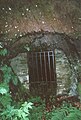
Outlet opening of the Wöhlersberg watercourse

Outlet opening of the Adlersberg-Nord watercourse


See also
Individual evidence
- ↑ a b c The Lautenthaler Kunstgraben. Retrieved February 8, 2016 .
- ^ A b Calvör: Acta Historico-Chronologico-Mechanica circa metallurgiam in Hercynia superiori. 1763, p. 89 f.
- ↑ a b c d The Lautenthaler Kunstgraben. Retrieved February 9, 2016 .
- ↑ Dennert-Tanne 10 (Lautenthal-BGV). Retrieved February 8, 2016 .
- ↑ Lautenthaler Kunstgraben. (No longer available online.) Archived from the original on February 9, 2016 ; accessed on February 9, 2016 . Info: The archive link was inserted automatically and has not yet been checked. Please check the original and archive link according to the instructions and then remove this notice.
literature
- Henning Calvör : Acta Historico-Chronologico-Mechanica circa metallurgiam in Hercynia superiori . Verlag der Fuerstl. Waysenhaus bookstore, Braunschweig 1763.
Coordinates: 51 ° 51 ′ 13.4 " N , 10 ° 16 ′ 38.9" E