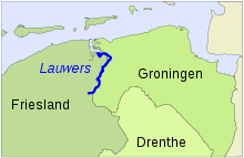
Lauwers
The Lauwers ( Gronings Laauwers ; outdated German Laubach or Laubeke ) is a 40 kilometer long river in the north of the Netherlands .
River course
The source of the Lauwers is near the village of Surhuisterveen ( West Frisian Surhústerfean ) in the Dutch province of Friesland . After a few kilometers, it meets the border between the provinces of Friesland and Groningen to the east and forms this to the north. At Gerkesklooster / Stroobos the Lauwers crosses the Prinses-Margriet Canal and the Van Starkenborgh Canal . Finally it flows behind Zoutkamp into the bay of the Lauwerszee and empties into the North Sea between the West Frisian islands Schiermonnikoog and Rottumeroog / Rottumerplaat . The gully between these islands can be seen as an extension of the Lauwers and bears the same name.
Historical meaning
The Lauwers is considered the historical border between western and eastern Friesland . As early as the 8th century, the so-called Westlauwerschen and Ostlauwerschen Frieslande were mentioned in the Lex Frisionum . Even today, the Lauwers separates the current Dutch province of Friesland (not to be confused with historic Friesland ) from the province of Groningen . The self-designation of the Frisians in the province of Friesland is Westlauwers'sche Friesen to this day .
Web links
Coordinates: 53 ° 15 ' N , 6 ° 14' E
