Le Petit Train du Jardin d'Acclimatation
|
|
|
|---|---|
|
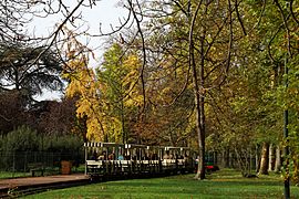
The ligne du jardin d'acclimatation, 2009
| |
|
Route
| |
| Route length: | 1.6 km |
| Gauge : | 500 mm ( narrow gauge ) |
Le Petit Train du Jardin d'Acclimatation is a 1.6 km long narrow-gauge railway with a gauge of 500 mm in the Bois de Boulogne in Paris .
Geographical location
The train runs from Porte Maillot to the Jardin d'Acclimatation , a landscape and leisure park within the Bois de Boulogne .
history
World Exhibition 1878
The French narrow-gauge railway pioneer Paul Decauville wanted to present his field railway system, which relied on relatively easy-to-lay track elements and low-maintenance, robust vehicles, at the Paris World Exhibition in 1878 . To do this, he planned a route from the Trocadéro in the west to the military academy at the other end of the exhibition area on the central exhibition site on the Champ de Mars . However, this request was rejected. He then offered to build a stretch from the Porte Maillot to the Jardin d'Acclimatation in the Bois de Bologne, the exhibition site of the world exhibition for the agricultural sector, which was successful. The route was 2 km long and carried the exhibition visitors on a circular route . The trains traveled at a top speed of 15 km / h. On Sundays the number of passengers was up to 3000, who commented very positively on the experience. The route was dismantled again after the end of the exhibition. The cast iron platform roofing of the La Porte Maillot train station has been preserved on site to this day.
The second track

In 1880 another company relocated a line from Porte Maillot to Jardin d'Acclimatation. American trams pulled by ponies with 8 seats each drove on it, with the passengers sitting back to back on longitudinal benches across the direction of travel. The horse-drawn tram was replaced in 1910 by locomotives with internal combustion engines , the appearance of which simulated the appearance of steam locomotives . These pulled three to four passenger cars with transverse benches that allowed a view in the direction of travel. The appearance of the locomotives changed over the years, and at times it was reminiscent of Renault taxis.
In 1930 the route was shortened at both ends. The route has not been significantly changed since then.
Because of the petrol shortage during and after the Second World War , the petrol locomotives were replaced by battery-powered vehicles, which were probably used at the 1937 World Exhibition . Their rubber-tyred wheels ran off the rails. After the petrol shortage was overcome, the original locomotives were put back into service. In 1960 Renault built seven locomotives with two bogies each. Their structure was streamlined and colorful. They were 3.05 m long and 1.20 m wide, weighed 5 t each and had a top speed of 19 km / h with 55 hp. The passenger cars were still the ones from 1910, but from 1951 onwards a roof was added.
business
New electric locomotives were put into operation in 2010 and the superstructure was renovated in 2018 .
Web links
Individual evidence
- ^ A b Jean Robert, Les tramways parisiens. P. 498.
- ↑ Satellite image Google maps
- ↑ L'histoire du Jardin ( Memento of the original from September 7, 2012 in the web archive archive.today ) Info: The archive link was automatically inserted and has not yet been checked. Please check the original and archive link according to the instructions and then remove this notice. - See the section "En voiture!" Left
- ↑ Construction site sign on site. Thereafter, the train should run again from September 2018.
Coordinates: 48 ° 52 ′ 40.9 " N , 2 ° 16 ′ 7.8" E


