
Lechaue west of Todtenweis
|
NSG Lechaue west of Todtenweis
|
||
 Blooming meadow with a hunter's stand (2015) |
||
| location | Todtenweis , Aichach-Friedberg district , Bavaria , Germany | |
| surface | 140.64 hectares | |
| WDPA ID | 318721 | |
| Geographical location | 48 ° 30 ' N , 10 ° 52' E | |
|
||
| Setup date | 1992 | |

The Lechaue nature reserve west of Todtenweis is located east of the Lech, west of Todtenweis . It is 140.64 hectares and was placed under conservation on October 28, 1992.
The area is a floodplain forest complex within the protected landscape Lech riparian forest at Todtenweis and Rehling . It contains softwood floodplains with a distinctive flood channel relief. Due to its earlier use as litter meadows , larger burns have arisen. These open land areas are particularly characteristic of the nature reserve today and contain species-rich lawns with alternatingly moist tuberous thistle-pipe grass meadows (Cirsio tuberosi-Molinietum). They are kept open by Mahd and are to be gradually expanded as part of the Lechtal project . There are numerous high seats for hunters on the meadows .
In addition, the nature reserve, which is part of the Lechtal biotope bridge , contains a near-natural Aubach ("wall water") and some regenerated waste water .
Path and boundaries
There is a walkable path that leads from the east into the nature reserve to the ponds.
In the west, the nature reserve is protected by a dam against the Lech. In the east there are fields, here the area is demarcated with a low electric fence .

Sign at the south end of the nature reserve

Dam in the west
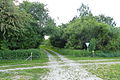
Way from the east to the nature reserve (over a low electric fence)
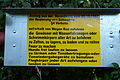
Notice of prohibitions

Autumn crops bloom on the mown meadows in autumn

Regenerated pond in the nature reserve


See also
Web links
- Information page of the government of Swabia , with map