Likouala-aux-Herbes
| Likouala-aux-Herbes | ||
|
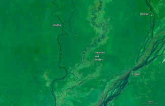
The Likouala-aux-Herbes in the catchment area of the Sangha (bottom right) |
||
| Data | ||
| location |
|
|
| River system | Congo | |
| Drain over | Sangha → Congo → Atlantic | |
| source | About 70 km south of the border with the Central African Republic 2 ° 22 ′ 0 ″ N , 17 ° 8 ′ 0 ″ E |
|
| Source height | approx. 400 m | |
| muzzle | in the Sangha coordinates: 0 ° 52 ′ 17 ″ S , 17 ° 8 ′ 0 ″ E 0 ° 52 ′ 17 ″ S , 17 ° 8 ′ 0 ″ E |
|
| Mouth height | 295 m | |
| Height difference | approx. 105 m | |
| Bottom slope | approx. 0.26 ‰ | |
| length | over 400 km | |
| Discharge at the Botouali A Eo gauge : 24,800 km² Location: 50 km above the mouth |
MQ Mq |
280 m³ / s 11.3 l / (s km²) |
|
The mouth of the Likouala-aux-Herbes |
||
The Likouala-aux-Herbes is a river in the Republic of the Congo .
course
It rises about 70 km south of the border with the Central African Republic in the Likouala department at an altitude of about 400 meters. It has only a slight gradient and therefore meanders very strongly. The river flows mainly in a southerly direction until it flows into the Sangha after about 400 km as the crow flies .
The Likouala-aux-Herbes is to be distinguished from the Likouala River , which shares its mouth with the Sangha about 50 km after the mouth of the Likouala-aux-Herbes.
Protected areas
Directly on the river is the 4400 km² Réserve Communautaire du Lac Télé / Likouala-aux-Herbes Ramsar conservation area with the Tele lake in its center.
Trivia
The Mokele-Mbembe , a mythical being, is said to live in the primeval forests around the lake and river.

