Lippert Peak
| Lippert Peak | ||
|---|---|---|
|
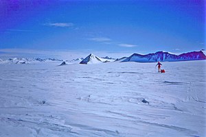
The Horseshoe Valley with Lippert Peak in the center and the Enterprise Hills in the background. |
||
| height | 1330 m | |
| location | Ellsworthland , West Antarctica | |
| Mountains | Heritage Range , Ellsworth Mountains | |
| Coordinates | 79 ° 59 ′ 0 ″ S , 81 ° 56 ′ 0 ″ W | |
|
|
||
The Lippert Peak is an acute, rocky and 1,330 m high summit in the Heritage Range , the southern half of the Ellsworth Mountains in West Antarctic Ellsworth Land . It rises at the end of a ridge that extends west from Douglas Peaks into the icy Horseshoe Valley . Only about 100 to 150 meters of its total height are visible beyond the ice masses surrounding it.
The United States Geological Survey mapped it using its own surveys and aerial photographs of the United States Navy from 1961 to 1966. The Advisory Committee on Antarctic Names named it in 1966 after George E. Lippert, who was part of the United States Antarctic Research Program 1965 worked on the Palmer station .
Individual evidence
- ↑ a b Lippert Peak ( English ) In: Geographic Names Information System . United States Geological Survey . Retrieved July 16, 2010.

