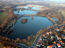
List of the Riddagshausen ponds
The list of Riddagshausen ponds includes the usually artificially created ponds in the Riddagshausen nature reserve and in the adjacent Buchhorst nature reserve . The ponds run off via the Fischergraben, Weddeler Graben and Mönchsteichgraben towards the west to the honeycomb .
The list is sorted alphabetically.
Ponds in the nature reserve
Hop pond
- Location: North of the Nehrkornweg and east of Haus Entenfang
- Area: 0.44 ha
- Altitude: 77 m above sea level NHN
- Use: biotope
- Specialty:
- Coordinates: ( map )
Jürgensteich
- Location: On the western edge of the Schapenbruch pond , hall Hasselteich
- Area: 0.12 ha
- Altitude: 76 m above sea level NHN
- Use: fish pond
- Special feature: not accessible to the public, path closed
- Coordinates: ( map )
Cross pond
- Location: Immediately on Ebertallee
- Area: 12 ha
- Altitude: 75 m above sea level NHN
- Use: fish pond
- Special feature: popular ice skating area
- Coordinates: ( map )
Lagesteich

Lagesteich north side with the Mönch drainage structure and information board
- Location: South of the monastery grounds on Kleiderseller away
- Area: 1.25 ha
- Altitude: 75.5 m above sea level NHN
- Use: fish pond
- Specialty:
- Coordinates: ( map )
Middle pond
- Location: between Kreuzteich and Schapenbruch pond
- Area: 10 ha
- Altitude: 75 m above sea level NHN
- Use: fish pond
- Specialty:
- Coordinates: ( map )
New Bleeksteich
- Location: East of the Kreuzteich on Dr.-Wilke-Weg
- Area: 1.41 ha
- Altitude: 76 m above sea level NHN
- Use: fish pond
- Specialty:
- Coordinates: ( map )
Reinertsteich
- Location: on the northern edge of the nature reserve
- Area: 0.68 ha (6,800 m²)
- Altitude: 77 m above sea level NHN
- Use: fish pond
- Special feature: edge area blocked for public access.
- Coordinates: ( map )
Pond between Reinertsteich and Schapenteich
- Location: East of the Reinertsteich, Schapenkamp corridor
- Area: 1.42 hectares
- Altitude: 77 m above sea level NHN
- Use: biotope
- Special feature: system around 2000
- Coordinates: ( map )
Schapenteich
- Location: West of Schapen
- Area: 0.58 ha
- Altitude: 78 m above sea level NHN
- Use: biotope
- Specialty:
- Coordinates: ( map )
Schapenbruch pond
- Location: Expansion between Gliesmarode and Schapen
- Area: 21 ha
- Altitude: 75.4 m above sea level NHN
- Use: shallow water with islands
- Special feature: Largest pond with many dry areas. See also nature reserve Riddagshausen, Schapenbruchteich .
- Coordinates: ( map )
Pointed pond
- Location: Between the monastery grounds and the Grüner Jäger restaurant on Kleidersellerweg
- Area: 0.76 ha
- Altitude: 75.5 m above sea level NHN
- Use: fish pond
- Special feature: tapered shape
- Coordinates: ( map )
Wiedigsteich
- Location: North-east of the Kreuzteich in the visual axis of the Dr.-Wilke-Weg
- Area: 0.75 ha (excluding the water area north of the dam)
- Altitude: 76 m above sea level NHN
- Use:
- Specialty:
- Coordinates: ( map )
Ziegelkampteich
- Location: Ziegelkamp, on the western edge of the Schapenbruch pond
- Area: 0.26 ha
- Altitude: 76 m above sea level NHN
- Use: fish pond
- Special feature: not freely accessible
- Coordinates: ( map )
Ponds in the Buchhorst landscape protection area
Rump pond
- Location: western edge of the Buchhorst Im Kaulenfelde
- Area: 0.92 ha
- Altitude: 79 m above sea level NHN
- Use: fish pond
- Special feature: Bounded by the former railway embankment, several tributaries from forest trenches, one of which is designated as a natural monument ND-BS28, drainage to the honeycomb
- Coordinates: ( map )
Monk ponds
- Location: western outskirts of Klein Schöppenstedt Am Springberge
- Area: 0.19 ha
- Altitude: 87 m above sea level NHN
- Use: fish pond
- Special feature: group of ponds, middle pond silted up, drain to the Kaulenteich
- Coordinates: ( map )
Outside the protected areas
The Lünischteich was also created by the monks of the monastery and is located in the area of the Riddagshausen district. However, it does not belong to the Riddagshausen nature reserve or the Buchhorst nature reserve.
See also
Web links
- City map 1: 5000 City of Braunschweig, OpenGeoData, accessed on September 18, 2016
- GeoLife LGLN State Office for Geodata, accessed on March 14, 2015
Footnotes
- ↑ The area and height information is determined from the official map of the Lower Saxony state survey with a scale of 1: 5,000 with appropriate accuracy.


