
Weddeler Graben
| Weddeler Graben | ||
 View into the floodplain of the Weddeler Graben, in the foreground the Schapener Graben |
||
| Data | ||
| Water code | DE : 482888 | |
| location | Germany , Lower Saxony , district Wolfenbüttel and Braunschweig | |
| River system | Weser | |
| Drain over | Wabe (Schunter) → Schunter → Oker → Aller → Weser → North Sea | |
| source |
Weddeler Wohld near Schandelah 52 ° 15 ′ 32 ″ N , 10 ° 39 ′ 49 ″ E |
|
| Source height | 95 m above sea level NHN | |
| muzzle |
Riddagshausen coordinates: 52 ° 16 ′ 11 " N , 10 ° 34 ′ 12" E 52 ° 16 ′ 11 " N , 10 ° 34 ′ 12" E |
|
| Mouth height | 75 m | |
| Height difference | 20 m | |
| Bottom slope | 2.7 ‰ | |
| length | 7.4 km | |
| Catchment area | 13.82 km² | |
| Right tributaries | Schapener Graben | |
| Flowing lakes | Weddeler pond | |
| Big cities | Braunschweig | |
| Communities | Cremlingen | |
| NLWKN water body number 15040 | ||
The Weddeler Graben is a 7 km long tributary of the honeycomb , which flows through the nature reserves Weddeler Teich and Riddagshausen . Its lowland between Weddel and Buchhorst forms an important part of the Riddagshausen nature reserve, where it and its tributary, the Schapener Graben , are dammed into a wet meadow. Both bodies of water pass the Riddagshausen ponds, in whose irrigation and drainage system they are integrated. The Weddeler Graben flows into the honeycomb from the right in the locality of Riddagshausen.
geography
The origin of the trench is in the Weddeler Wohld forest west of Schandelah . At the southern edge of the forest area, its regularly dry-falling bed extends westward, turns north on state road 635 between Cremlingen and Hordorf and turns to the northwest. After another 500 meters, it reaches the Weddeler Teich nature reserve, in which it is divided: one arm delimits the area to the south, while another flows through the pond and reunites at the western edge of the pond after a passage through the final dam. The ditch passes Weddel south, is crossed by the district road 141 and the Braunschweig – Magdeburg railway line and flows mainly in a westerly direction to the mouth.
To the southwest of Weddel, it enters the Riddagshausen nature reserve and the city of Braunschweig . In the grave valley named after him, the Schapener Graben flows north of the Weddeler Graben mainly parallel to the west. This is fed by trenches from the direction of Schapen. In the course of renaturation measures, a branch was made from Weddeler Graben to Schapener Graben, in which there are numerous pond-like widenings. As a result, the Schapener Graben generally carries more water than the main body of water, which is partially dry along the Buchhorst. Near the former railway line to Schöningen , a viewing area has been created from which the flora and fauna in the lowlands can be observed. The adjacent forest is kept moist by dammed water. Extensive livestock farming is carried out in the forest and meadow areas.
To the west of the former railway embankment, both bodies of water are crossed by two footpaths and cycle paths and can be seen more closely by walkers, the Schapener Graben runs along the Dr.-Wilke-Weg. It receives a tributary from the area of the Schapenbruch pond ( Schapenerteichgraben ) and its structure is in parts natural. The Weddeler Graben runs south of it on the edge of the forest of the Buchhorst and includes a meadow with the Schapener Graben.
After several hundred meters, the Schapener Graben flows into the Weddeler Graben in front of a wooden weir, both lined with trees and numerous bank vegetation. The Weddeler Graben continues in a very straight line, its branches feed the hop pond and the cross pond . He turns a little to the south and passes the Entenfang house, whose access from the Nehrkornweg leads over a footbridge. It continues east of the Neuer Bleeksteich , where it disappears in a structure below the surface. From there it crosses under Ebertallee and is piped under the footpath on its south side to the bridge over the honeycomb, where it flows into it.
Water quality
The Schunter entertainment association and the city of Braunschweig are responsible for water maintenance, the latter for the approximately 3.6 km long section in the city area. The Stadtentwässerung Braunschweig GmbH responsible for this area has commissioned the Institute for Geoecology at the TU Braunschweig with the assessment of the water structure quality and the biological quality for several years . In terms of structural quality, the 2015 annual report comes to positive results for the Weddeler and Schapener Graben. This mainly relates to the renatured area of the grave valley within the nature reserve, where sections of near-natural courses have been mapped. This concerns the morphology and the bank design including dead wood deposits and vegetation. Overall, the sections with moderate and significant impairments predominate. The lower piped section in the Riddagshausen local area is, as expected, classified as alien.
Picture gallery


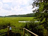
View from the south over the grave valley west of Weddel
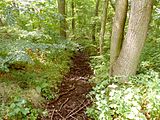
Weddeler Graben on the edge of the Buchhorst, summer 2016

Schapener Graben, view upstream to the former embankment, 2016
Viewing platform on the edge of the grave valley, 2016
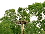
Pair of storks in the floodplain, 2016


Web links
- Map display of the Weddeler and Schapener trenches at openstreetmap.org
- Publications of the state of Lower Saxony on the water quality of the Oker and its tributaries on wasserblick.net
- List of water bodies in the Outer catchment area with data (PDF) Publication of the NLWKN on wasserblick.net
- Water quality report Oker 2002 (PDF) Internet platform of the NLWKN
- Experience nature in Riddagshausen City of Braunschweig, with a link to information brochures for children and adults, accessed on September 9, 2016
Individual evidence
- ↑ a b LGLN : Topographic Map 1: 50,000 , as of 2000, CD-ROM Top50 Viewer
- ↑ a b List of water bodies in the Outer catchment area with data. (PDF) Retrieved March 2, 2014 .
- ↑ NLWKN : Water quality report Oker 2002. Braunschweig October 2002, p. 84 ff., Section Weddeler Graben.
- ↑ a b GeoLife. (No longer available online.) Archived from the original on March 19, 2015 ; accessed on March 14, 2015 . Info: The archive link was inserted automatically and has not yet been checked. Please check the original and archive link according to the instructions and then remove this notice.
- ↑ NLWKN : Area directory for the Lower Saxony hydrographic map. Status 2010, p. 72. FV_Weser.pdf, retrieved from Umwelt.niedersachsen.de on August 19, 2013.
- ↑ a b Institute for Geoecology, TU Braunschweig, Diana Goertzen: Water structure quality and water quality studies in flowing waters in the area of the city of Braunschweig, annual report 2015. Braunschweig 2015, p. 40 ff.
- ^ City drainage Braunschweig: Umweltatlas Braunschweig. Braunschweig 2007, p. 35: Map 8/1 Rain and mixed water sewers.
- ↑ Note: In the Weser land register, a section of the honeycomb between Ebertallee and Weddeler Graben is specified (GKZ 4828879), which suggests that the outflow from the Kreuzteich is classified as Weddeler Graben. In the (unofficial) Google Maps this section is also referred to as “Weddelergraben”.