
Weddeler pond
| Weddeler pond | ||
|---|---|---|

|
||
| Weddeler Teich, October 2012 | ||
| Geographical location | Wolfenbüttel district , Lower Saxony | |
| Drain | Weddeler Graben | |
| Places on the shore | Fronds | |
| Location close to the shore | Braunschweig | |
| Data | ||
| Coordinates | 52 ° 16 '2 " N , 10 ° 37' 51" E | |
|
||
| Altitude above sea level | 81.1 m above sea level NN | |
| length | 400 m | |
| width | 200 m | |
|
particularities |
||

The Weddeler Teich is a dammed pond and a nature reserve in the Lower Saxony municipality of Cremlingen in the Wolfenbüttel district .
Nature reserve
The nature reserve with the registration number NSG BR 041 is 20 hectares in size. It south of Weddel , a village in the municipality of Cremlingen east of Braunschweig . It includes the pond and the surrounding bank area. The relatively shallow, eutrophic pond was dammed in the Weddeler Graben valley and used as a carp pond for centuries . The pond is partially silted up . He is by extensive reed - and cattail - reeds surrounded, followed by an wetland connects.
The reeds of the Weddeler Teich are breeding and resting areas for many bird species , the wetland habitat for a large number of animal species, some of which are endangered.
The nature reserve is for the most part surrounded by agricultural land . A few hundred meters to the west is the " Riddagshausen " nature reserve , with which it forms a unit.
The area has been a nature reserve since February 16, 1981. The responsible lower nature conservation authority is the Wolfenbüttel district.
Picture gallery
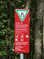
Sign at the pond, 2012

North area, July 2012

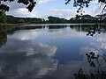
View of the northeast bank, 2012
.jpg)


See also
Web links
- Nature reserve "Weddeler Teich" in the database of the Lower Saxony State Office for Water Management, Coastal and Nature Conservation (NLWKN)


Ducal Mountains | Limestone quarry and semi-arid grassland on the Eich mountain near Hemkenrode | Klotzberg | Middle Innerstetal with Kanstein | Oker and Eckertal in the districts of Goslar and Wolfenbüttel | Reitlingstal | Remlinger Heerse | Barnstorf salt marsh | Baddeckestedt quarry | Weddeler pond