Litene
| Litene ( German : Lettin) | ||
|---|---|---|
 Help on coat of arms |
|
|
| Basic data | ||
| State : |
|
|
| Landscape: | Livonia ( Latvian : Vidzeme ) | |
| Administrative district : | Gulbenes novads | |
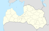
| Coordinates : | 57 ° 11 ' N , 27 ° 1' E | |
| Residents : | 1,140 (Sep 1, 2012) | |
| Area : | 0.98 km² | |
| Population density : | 1,163 inhabitants per km² | |
| Height : | 113 m | |
| Website: | www.litene.lv | |
| Post Code: | ||
| ISO code: | ||
Litene is a settlement in the Litene municipality in the Gulbene district of Livonia with 1140 inhabitants.
geography
Litene is located at an altitude of 113 m on the right bank of the Pededze .
history
The settlement was built near the former Litene mansion, which lies on the border between the Swedish Vidzeme and the Polish Vidzeme (later in the Vidzeme Province and the Vitebsk Province).
In June 1941, the first year of the Soviet occupation, 200 Latvian officers were shot and 560 deported to Siberian gulags at an army summer training camp in Litene . In 1990 the remains of 11 former officers were exhumed .
In June 2001, the Latvian Defense Minister Ģirts Valdis Kristovskis opened a memorial to the officers of the Latvian army who were killed in Litene.
Infrastructure
Litene is on State Road 35 from Gulbene to the Vientuli border crossing . The state road 43 to Alūksne branches off here. The state capital Riga is about 3 hours away.
Individual evidence
- ↑ Vispārīgas ziņas | Litenes pagasts. Retrieved June 21, 2019 (lv-LV).
- ^ Archeology of Terror. Retrieved June 21, 2019 .

