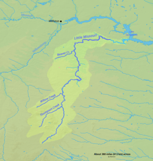
Little Missouri River, North Dakota
| Little Missouri River | ||
|
Little Missouri River in Theodore Roosevelt National Park |
||
| Data | ||
| Water code | US : 1034981 | |
| location | Montana , North Dakota , South Dakota , Wyoming (USA) | |
| River system | Mississippi River | |
| Drain over | Missouri River → Mississippi River → Gulf of Mexico | |
| source | in Crook County , Wyoming, 44 ° 32'25 " N , 104 ° 59'57" W. |
|
| muzzle | in North Dakota in Lake Sakakawea Coordinates: 47 ° 36 '38 " N , 102 ° 52' 24" W 47 ° 36 '38 " N , 102 ° 52' 24" W.
|
|
| length | 901 km | |
The Little Missouri River is a 901-kilometer tributary of the Missouri River in the northern Great Plains of North America .
course
It rises in the northeast of the US state Wyoming , about 35 kilometers west of Devils Tower in Crook County . It then flows continuously northeast, cutting a corner of Montana, and then reaching South Dakota , where it flows through the Badlands in a northbound direction to North Dakota . The river crosses the Little Missouri National Grassland , as well as the two parts of the Theodore Roosevelt National Park , in the northern part of which it turns east again and flows into Lake Sakakawea . There it forms an arm of the reservoir 30 miles long, called Little Missouri Bay, which reaches the main Missouri canal about 25 miles north of Killdeer .

