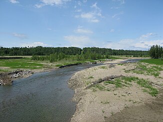
Little Red Deer River
| Little Red Deer River | ||
| Data | ||
| location | Alberta (Canada) | |
| River system | Nelson River | |
| Drain over | Red Deer River → South Saskatchewan River → Saskatchewan River → Nelson River → Hudson Bay | |
| Headwaters | eastern foothills of the Canadian Rockies 51 ° 26 ′ 21 ″ N , 115 ° 3 ′ 39 ″ W |
|
| Source height | approx. 1600 m | |
| muzzle |
Red Deer River Coordinates: 52 ° 3 '54 " N , 114 ° 8' 8" W 52 ° 3 '54 " N , 114 ° 8' 8" W. |
|
| Mouth height | approx. 900 m | |
| Height difference | approx. 700 m | |
| Bottom slope | approx. 4.2 ‰ | |
| length | approx. 165 km | |
| Catchment area | approx. 2590 km² | |
| Discharge at the Water Valley A Eo gauge : 451 km² Location: 125 km above the mouth |
MQ 1961/2015 Mq 1961/2015 |
1.9 m³ / s 4.2 l / (s km²) |
| Discharge A Eo : 2440 km² Location: 7.5 km above the mouth |
MQ 1961/2014 Mq 1961/2014 |
4.81 m³ / s 2 l / (s km²) |
| Right tributaries | Dogpound Creek | |
The Little Red Deer River is an approximately 165 km long right tributary of the Red Deer River in the west of the Canadian province of Alberta .
River course
The Little Red Deer River rises in the eastern foothills of the Canadian Rockies at an altitude of 1,600 m . The Little Red Deer River initially flows east through the foothills of the Rocky Mountains. The river then turns to the northeast and flows through the Great Plains to its confluence with the Red Deer River, 13 km west of Innisfail . The Red Lodge Provincial Park is 35 km above the estuary . Alberta Highway 22 crosses the river 9 km above the mouth .
Hydrology
The Little Red Deer River drains an area of approximately 2590 km². The effective catchment area covers around 2450 km². The mean discharge 7.5 km above the mouth is 4.81 m³ / s. June is the month with the highest discharge with an average of 12.6 m³ / s.
