Little Smoky River
| Little Smoky River | ||
|
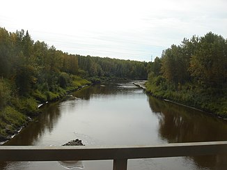
Little Smoky River south of Valleyview |
||
| Data | ||
| location | Alberta (Canada) | |
| River system | Mackenzie River | |
| Drain over | Smoky River → Peace River → Slave River → Mackenzie River → Arctic Ocean | |
| source | at the foot of the Canadian Rockies southeast of Grande Cache 53 ° 51 ′ 12 ″ N , 118 ° 22 ′ 52 ″ W |
|
| muzzle | south of Watino in the Smoky River Coordinates: 55 ° 40 ′ 25 " N , 117 ° 37 ′ 38" W 55 ° 40 ′ 25 " N , 117 ° 37 ′ 38" W
|
|
| length | approx. 350 km | |
| Discharge at the Guy A Eo gauge : 11,100 km² |
MQ 1959/2000 Mq 1959/2000 |
48 m³ / s 4.3 l / (s km²) |
| Left tributaries | Waskanigan River, Sturgeon Creek | |
| Right tributaries | Iosegun River, Goose River | |
|
Little Smoky River in the Peace River catchment |
||
The Little Smoky River is a right tributary of the Smoky River in the Canadian province of Alberta .
The Little Smoky River rises at the foot of the Canadian Rockies, southeast of Grande Cache . It initially flows in an easterly direction. About 20 km southwest of Fox Creek , the river changes direction to the north. After about 350 km the Little Smoky River reaches the Smoky River south of Watino . At the gauge near Guy , the mean discharge of the Little Smoky River is 48 m³ / s.
Web links
- Little Smoky River at the Little Smoky gauge - hydrographic data from R-ArcticNET
- Little Smoky River at the Triangle gauge - hydrographic data from R-ArcticNET
Individual evidence
- ↑ Little Smoky River at the Guy gauge - hydrographic data from R-ArcticNET

