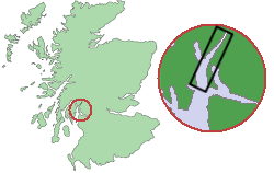
Loch Long (Argyll and Bute)
| Loch Long | |
|---|---|
| Waters | Firth of Clyde |
| Land mass | Great Britain (island) |
| Geographical location | 56 ° 2 ′ N , 4 ° 53 ′ W |
| width | 2.7 km |
| length | approx. 30 km |
|
View of Loch Long from the torpedo proving site |
|
Loch Long is a bay on the west coast of Scotland in the Council Area Argyll and Bute . In Scotland these bays are called Sea Lochs and denote lakes that are fed by sea water.
The Loch Long stretches from its southern end on the Firth of Clyde about 30 kilometers to the village of Arrochar at the northern tip of the bay. In the southern area the bay has a width of up to 2.7 kilometers, at the narrowest point in the north Loch Long measures less than 500 meters. Loch Goil branches off on the west side of the bay .
Historically, Loch Long marked the border between the traditional counties of Argyll and Dunbartonshire for a long time .
During the Second World War attempts were made with torpedoes in the northern part of the bay . Numerous wrecks still bear witness to these attempts . Today the area is a popular area for scuba divers.
The Finnart Oil Terminal is located on the east side of the bay. A pipeline around 100 kilometers in length runs from this terminal to an oil refinery in Grangemouth . The Royal Navy's Coulport Armament depot is also on the east side and is part of the Faslane-on-Clyde naval base .

