
Lock and Dam No. 11
| Lock and Dam No. 11 | |
|---|---|

|
|
| Weir | |
| Type: |
Segment weir roller weir |
| Maximum storage height: | 2.70 m |
| Dam length (moving part): | 450.50 m |
| lock | |
| usable length: | 182.90 m |
| usable width: | 33.50 m |
| Lock and Dam No. 11 Historic District | |||
|---|---|---|---|
| National Register of Historic Places | |||
| Historic District | |||
|
|||
| location |
Dubuque , Iowa Grant County , Wisconsin |
||
| Coordinates | 42 ° 32 '25 " N , 90 ° 38' 39" W | ||
| surface | 46.22 ha | ||
| Built | 1934-1937 | ||
| architect | Edwin E. Abbott W.A. Turner |
||
| NRHP number | 04000171 | ||
| The NRHP added | 2004 | ||

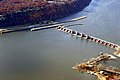
Lock and Dam No. 11 ( Lock and Barrage No. 11 ) is one of 29 barrages that enable navigation on the Upper Mississippi . Erected between 1934 and 1937 by the United States Army Corps of Engineers , the combined structure is located between Dubuque , Iowa and Grant County , Wisconsin . In 2004 the Lock and Dam No. 11 Historic District included in the NRHP .
Barrage
The barrage includes a 1018 m long stone dam on the Wisconsin side and a 450.5 m long adjustable part, which consists of a 13-part segment weir and three dam rollers .
The water level is nine feet (2.70 m). The purpose of the weir is not primarily to protect against flooding, but to damming the Mississippi for shipping.
lock
The lock is 182.9 m long and 33.5 m wide. Next to it is a second, but not completed, smaller lock chamber.
photos
View from Wisconsin to the Iowa shore

View from Dubuque Lock over the Weir to Wisconsin
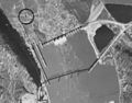
1940 aerial view of the former Eagle Point Bridge


