Longos Vales
| Longos Vales | ||||||
|---|---|---|---|---|---|---|
|
||||||
| Basic data | ||||||
| Region : | Norte | |||||
| Sub-region : | Alto Minho | |||||
| District : | Viana do Castelo | |||||
| Concelho : | Monção | |||||
| Coordinates : | 42 ° 3 ′ N , 8 ° 27 ′ W | |||||
| Residents: | 989 (as of June 30, 2011) | |||||
| Surface: | 14 km² (as of January 1, 2010) | |||||
| Population density : | 71 inhabitants per km² | |||||
| politics | ||||||
| Website: | www.longosvales.net | |||||
Longos Vales is a municipality ( freguesia ) in the northern Portuguese district of Monção .
989 inhabitants live in it (as of June 30, 2011).
Buildings
- Castro de Sao Caetano
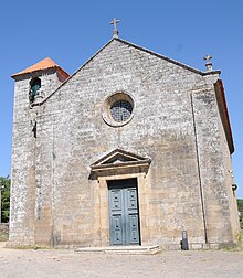
- Longos Vales Church
- Capela de Sao Caetano
Sons and daughters
- Antonino Eugénio Fernandes Dias (* 1948), Catholic bishop
Individual evidence
- ↑ a b www.ine.pt - indicator resident population by place of residence and sex; Decennial in the database of the Instituto Nacional de Estatística
- ↑ Overview of code assignments from Freguesias on epp.eurostat.ec.europa.eu
Web links
- Map of the Freguesia Longos Vales at the Instituto Geográfico do Exército


