Los Caños de Meca
| Municipality of Barbate: Los Caños de Meca | ||
|---|---|---|
 Los Caños de Meca
|
||
| coat of arms | Map of Spain | |
 Help on coat of arms |
|
|
| Basic data | ||
| Autonomous Community : | Andalusia | |
| Province : | Cadiz | |
| Coordinates | 36 ° 11 ′ N , 6 ° 1 ′ W | |
| Residents : | 294 (2011) INE | |
| Area code: | 11007000200 | |
| Location of the place | ||

|
||
Los Caños de Meca is a place on the Costa de la Luz in the south of the Andalusian province of Cádiz ( Spain ), 40 km southeast of the provincial capital of Cádiz , at the northwest end of the Strait of Gibraltar .
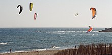
Los Caños connects to the east of the headland of Cape Trafalgar , in front of which the Battle of Trafalgar was fought on October 21, 1805 . The wide sandy beach, the dunes and above all the waves and the strong east wind blowing onshore ( Levante ) make the bay a popular destination for kite and windsurfers despite some stone reefs and strong ocean currents .
The pine forests and the two-kilometer long cliffs of the Parque Natural de La Breña y Marismas del Barbate , which has a rich flora and fauna, extend between Los Caños and the neighboring town of Barbate to the east . The cliffs reach a height of up to 100 meters at the watchtower Torre del Tajo from the 16th century.
The name of the place Los Caños goes back to the small aquifers (Caños) that emerge from the cliffs behind the eastern end of the village from the steep walls. Lush green has settled where the water runs down the rocks into the sea. Depending on the amount of rain and the season, they can grow into a waterfall. Most important is the Caño grande , which lies behind a few small bays in Cala Verde and is only accessible at low tide (surefootedness and use of hands required).
Web links
Individual evidence
- ↑ Parque Natural de La Breña y Marismas del Barbate (Spanish Wikipedia)

