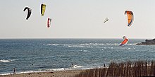
Costa de la Luz
| Basic data | |
|---|---|
| Country : | Spain |
| in the provinces : | Cadiz , Huelva |
| Length : | approx. 200 km |
Costa de la Luz [ ˈkosta ðe la ˈluθ ] ( Spanish for "coast of light") refers to the southern Spanish Atlantic coast on the Gulf of Cádiz between the Spanish- Portuguese border formed by the Guadiana river near the city of Huelva and the southernmost tip of Spain (and thus the European mainland) at Tarifa . At Tarifa, where Spain is only about 14 km from Morocco ( Africa ), it merges into the Strait of Gibraltar and the Costa del Sol .
The mouth of the Guadalquivir with the Coto de Doñana National Park divides the Costa de la Luz into two parts. The area southeast of the estuary belongs to the province of Cádiz , the northwest part of the province of Huelva .
The beaches on the Costa de la Luz usually consist of endless dunes with fine sand, which are fortified by native plants. Near the coast are the pine forests typical of Andalusia . The region lives mainly from tourism in summer. The Costa de la Luz is not only a popular holiday destination for Spaniards, but also very popular with the French, English and Germans, who make up the majority of foreign tourists.
Significant locations along or near the coast include a. (from west to east): Ayamonte and Huelva in the province of Huelva as well as Chipiona , Rota , Cádiz , El Puerto de Santa María , Jerez de la Frontera , Chiclana de la Frontera , Conil de la Frontera , Vejer de la Frontera , Los Caños de Meca , Barbate and Tarifa in the province of Cádiz.
Web links
- Information about the Costa de la Luz - official website for tourism in Spain (German)
- News for the Costa de la Luz (German)
Individual evidence
- ↑ Franceses, alemanes e ingleses, los turistas más interesados en alquilar casa en España Accessed on April 10, 2014
- ↑ Costa de la Luz, accessed on March 11, 2015

