
Lunan Water
| Lunan Water | ||
 |
||
| Data | ||
| location | Angus , Scotland | |
| source | Outflow from Rescobie Hole 56 ° 39 ′ 9 ″ N , 2 ° 46 ′ 30 ″ W. |
|
| Source height | 60 m ASL | |
| muzzle |
Lunan Bay , 6.5 km south of Montrose Coordinates: 56 ° 38 ′ 58 " N , 2 ° 30 ′ 12" W 56 ° 38 ′ 58 " N , 2 ° 30 ′ 12" W |
|
| Mouth height | 0 m ASL | |
| Height difference | 60 m | |
| Bottom slope | 2.9 ‰ | |
| length | 21 km | |
| Flowing lakes | Balgavie's hole | |
Lunan Water is a river in the Scottish Council Area Angus . It is not to be confused with the Lunan Burn in the neighboring county of Perth and Kinross .
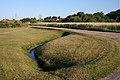
The river flows east from Rescobie Loch and after about 500 m reaches the nearby Balgavies Loch . He leaves this again in an easterly direction. The Lunan Water flows further east to its mouth and runs through sparsely populated, rural areas. It passes Friockheim and finally flows into Lunan Bay after a total of 21 km near the hamlet of Lunan , about 6.5 km south of Montrose . The difference in height between the source and the mouth is 60 m. Its main tributary is the Vinnie . In the 19th century, trout and few salmon populated Lunan Water.
Upper course of the Lunan Waters

Mouth of the Lunan Waters


Web links
Individual evidence
- ↑ a b Lunan Water. In: Francis H. Groome: Ordnance Gazetteer of Scotland: A Survey of Scottish Topography, Statistical, Biographical and Historical. Volume 5: (Lib - Pet). Thomas C. Jack, Grange Publishing Works, Edinburgh et al. 1884, p. 565.
- ↑ a b Lunan Water. In: David Munro, Bruce Gittings: Scotland. An Encyclopedia of Places & Landscapes. Collins et al., Glasgow 2006, ISBN 0-00-472466-6 .