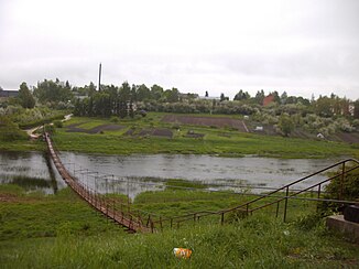
Mūša
|
Mūša Mūsa |
||
| Data | ||
| location | Lithuania , Latvia | |
| River system | Magnifying glass | |
| Drain over | Lielupe → Gulf of Riga | |
| Mūšos tyrelis (Musa Swamp) | Joniškis County , Lithuania 56 ° 12 ′ 38 ″ N , 23 ° 13 ′ 1 ″ E |
|
| Source height | approx. 90 m | |
| Association with | Mēmele ( Nemunėlis ) to Lielupe Coordinates: 56 ° 24 ′ 10 ″ N , 24 ° 9 ′ 35 ″ E 56 ° 24 ′ 10 ″ N , 24 ° 9 ′ 35 ″ E |
|
| Mouth height | approx. 8 m | |
| Height difference | approx. 73 m | |
| Bottom slope | approx. 0.45 ‰ | |
| length | 164 km (284 km together with Lielupe) | |
| Catchment area | 5320 km² | |
|
The mūsa at Pasvalys in Lithuania |
||
|
Mūsa Bridge near Bauska |
||
The Mūša ( Latvian Mūsa ) is a river in Lithuania and Latvia .
It rises in the Mūšos tyrelis bog of the same name near Žagarė in the northern Lithuanian district of Joniškis and forms the border between Lithuania and Latvia over a length of six kilometers. After a further 18 km, it joins the Mēmele (Lithuanian: Nemunėlis ) at Bauska , which also rises in Lithuania. From here on the river is called Lielupe , “large river”. The banks of the calmly flowing river are overgrown with reeds in many places . The valley becomes a little deeper near the mouth.
Tributaries are Vilkvedis (LT), Voverkis (LT), Kulpė (LT), Kruoja (LT), Daugyvenė (LT), Mažupė (LT), Lėvuo (LT), Pyvesa (LT), Viekšmuo (LT), Tatula (LT ) and Ceraukste (LV).


