Nemunėlis
|
Nemunėlis Mēmele |
||
| Data | ||
| location | Lithuania , Latvia | |
| River system | Magnifying glass | |
| Drain over | Lielupe → Gulf of Riga | |
| source | Rokiškis County , Lithuania 55 ° 54 ′ 36 ″ N , 25 ° 36 ′ 9 ″ E |
|
| Source height | approx. 132 m | |
| Association with | Mūsa ( Mūša ) to Lielupe near Bauska (Latvia) Coordinates: 56 ° 24 ′ 9 ″ N , 24 ° 9 ′ 26 ″ E 56 ° 24 ′ 9 ″ N , 24 ° 9 ′ 26 ″ E |
|
| Mouth height | approx. 7 m | |
| Height difference | approx. 125 m | |
| Bottom slope | approx. 0.65 ‰ | |
| length | 191 km | |
| Catchment area | 4047 km² | |
| Drain |
MNQ MQ HHQ |
30 m³ / s 95 m³ / s 341 m³ / s |
|
The Mēmele at Bauska |
||
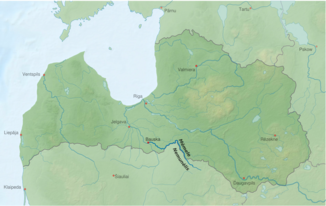
The Nemunėlis ( Latvian Mēmele ) is a river in Lithuania and Latvia .
It rises in Lake Lušna near Rokiškis . The river forms the natural border between Lithuania and Latvia for 76 km. At Bauska it flows together with the Mūša (Latvian Mūsa ), which also rises in Lithuania. From here on the river is called Lielupe , “large river”. In the middle part, the river has formed a wide, deep valley, otherwise it runs through flat lowlands.
From Panemunis the river is navigable by boat.
Tributaries include Beržuona , Apašča , Vīžona , Dienvidsusēja (114 km), Viesīte (59 km), Nereta (25 km), and Rīkonu strauts (18 km).
Web links
Commons : Nemunėlis - collection of images, videos and audio files

