
M4 (Istanbul Metro)


The M4 line (not to be confused with the light rail line T4 or "Hafif Metro", which is on the European side of the city) is an underground line of the Metro Istanbul on the Asian side of Istanbul. The line is operated by the local public transport company İstanbul Ulaşım and was opened on August 17, 2012. The plans go back to 2005, construction has been going on since 2010.
meaning
| Line M4 in data | |
|---|---|
| length | 26.5 km |
| Stations | 19th |
| of which underground | 19th |
| Stations under construction | 4th |
| Access | Barrier |
| operator | Istanbul Ulasim |
| Installation | 2012 |
| Terminals | Kadıköy - Tavşantepe |
| 24 hour operation | no (6.00 a.m. - 0.30 a.m.) |
The M4 line is important for commuter traffic from the Asian side of the city to Europe, where most of the companies and jobs are located. It currently ends at the Kadıköy ferry port. With the completion of the Marmaray - commuter train tunnel under the Bosporus on 29 October 2013 its importance will increase for the Eurasian shuttle. At the Ünalan station there is already a transfer option to the Metrobus , which connects Asia with Europe.
Course and operation
The route, which comprises 16 stations, runs completely underground in a south-easterly direction, along the densely populated areas under the D-100 expressway. At the Kadıköy terminus, you can change to the T3 tram line. In Ayrılıkçeşme you can walk to the İbrahimağa S-Bahn station. The trains initially run at 150-second intervals, which will later be converted to 90-second intervals. The longest distance between two stations is 2.3 km between Bostancı and Küçükyalı. The one between Maltepe and Huzurevi stations, at just 800 meters, is the shortest.
Ward plan

The line identification color of the M4 on the network maps of the Istanbul Ulasim public transport company is pink.
Expansion and further development
Even if an exact date has not yet been set, it is firmly planned that the route in the south-east will be extended by three stations first to Pendik and in a further step via Kaynarca to Tersane. By 2019, a new metro line is to be built from the Pendik (Marmaray) S-Bahn station to Sabiha Gökçen Airport , which will cross the M4 at Kaynarca-Merkezı station. This would connect the airport directly to the subway and the transcontinental high-speed train system, and passengers from Sabiha Gökcen Airport could get to the European side of the city without having to travel by bus.
gallery

M4 route plan

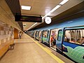
The interior of an M4 train
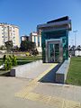
Elevator at Kozyatağı Station
The Yenisahra Station

The Ünalan station in black as the main color

The three-track Bostancı station

An underpass in Bostancı Station


swell
- ↑ http://www.railwaygazette.com/news/urban-rail/single-view/view/kadikoey-kartal-metro-opened-by-prime-minister.html
- ↑ http://www.urbanrail.net/as/tr/istanbul/istanbul.htm
- ↑ http://www.istanbul-ulasim.com.tr/raylı-sistemler/m4-kadıköy-kartal.aspx
- ↑ Archived copy ( memento of the original from August 24, 2013 on WebCite ) Info: The archive link was inserted automatically and has not yet been checked. Please check the original and archive link according to the instructions and then remove this notice.
- ↑ Her Yerde Metro, Metro Her Yere (2013). Istanbul'un Metrosu Broşür. İstanbul Büyükşehir Belediyesi, p. 21 f.
- http://www.istanbul-ulasim.com.tr/raylı-sistemler/m4-kadıköy-kartal.aspx Information from İstanbul Ulaşim
- http://www.ibb.gov.tr/tr-tr/subsites/raylisistemler/pages/kadikoy-kartal.aspx Information from the Istanbul City Council
- http://adcdn.noc.com.tr/70fb6fcb0ed3058931a0a3d55233ac34.swf ( Flash ; 223 kB)
- http://www.ibb.gov.tr/tr-TR/SubSites/raylisistemler/Pages/kadikoy-kartal120.aspx
- http://www.emlakkulisi.com/guncel/kadikoy-kartal-metrosu-ayrilikcesme-istasyonu-ihalesi/64336
- http://www.urbanrail.net/as/tr/istanbul/istanbul.htm
- http://www.railwaygazette.com/news/urban-rail/single-view/view/kadikoey-kartal-metro-opened-by-prime-minister.html
- http://www.istanbul.net.tr/istanbul-Haberler/kadikoy-kartal-metro-hatti-temmuzda-acilacak/750/1
- http://www.istanbul.net.tr/istanbul-Haberler/kadikoy-kartal-metro-hatti-temmuzda-acilacak/750/1
Coordinates: 40 ° 59 ′ 40.6 ″ N , 29 ° 4 ′ 6.1 ″ E