MacKenzie Bay
| MacKenzie Bay | ||
|---|---|---|
|
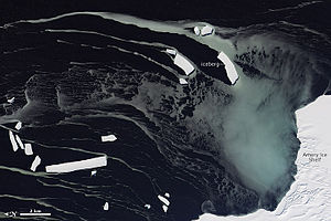
Satellite image of MacKenzie Bay with the adjacent Amery Ice Shelf |
||
| Waters | Cooperation lake | |
| Land mass | Mac Robertson Land , East Antarctica | |
| Geographical location | 68 ° 38 '0 " S , 70 ° 35' 0" E | |
|
|
||
The MacKenzie Bay is a small bay on the coast of the East Antarctic Mac Robertson Lands . It is an indentation of the western foothills of the Amery Ice Shelf and is located around 30 km northeast of the Foley Promontory .
Participants of the British Australian and New Zealand Antarctic Research Expedition (BANZARE, 1929-1931) under the direction of the Australian polar explorer Douglas Mawson sighted a much larger bay here on February 10, 1931, the extent of which they explored during an overflight. They gave this bay the name MacKenzie Sea after Kenneth Norman MacKenzie (1897-1951), skipper of the RSS Discovery on this research voyage from 1930 to 1931. Calving icebergs of the adjacent ice shelf gradually decreased the size of the bay over the years had a width of only 24 km. Other sightings took place parallel to the BANZARE by several Norwegian whalers, including the Seksern under Captain Arnold Brunvoll (1898–1932) on January 13, 1931 and the Torlyn under Captain Klarius Mikkelsen (1887 – unknown) on February 13, 1931. The name became the modified size of the object.
Web links
- MacKenzie Bay in the Geographic Names Information System of the United States Geological Survey (English)
- MacKenzie Bay on geographic.org (English)

