Mae Nam Kra Buri
|
Mae Nam Kra Buri Mae Nam Pak Chan; Myitkyina; Kyan |
||
|
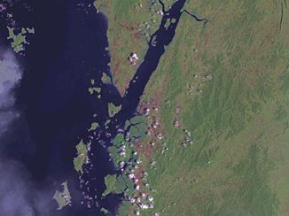
Satellite photo of the funnel mouth |
||
| Data | ||
| location | Southern Thailand , Southern Myanmar | |
| River system | Mae Nam Kra Buri | |
| source |
Tenasserim Mountains , Amphoe Kra Buri ( Ranong Province , Thailand) 10 ° 32 ′ 0 ″ N , 98 ° 42 ′ 0 ″ E |
|
| muzzle | At Ranong (Thailand) or Kawthaung (Myanmar) in the Andaman Sea coordinates: 9 ° 59 ′ 0 ″ N , 98 ° 35 ′ 0 ″ E, 9 ° 59 ′ 0 ″ N , 98 ° 35 ′ 0 ″ E |
|
| Mouth height |
0 m
|
|
| length | 70 km | |
The Mae Nam Kra Buri ( Thai : แม่น้ำ กระบุรี , “Kra Buri River”, or แม่น้ำ ปาก จั่น , Mae Nam Pak Chan ; Burmese မြစ်ကြီးနား , BGN / PCGN : myitkyina , “Kyan River”) is a river on the isthmus of Kra on the Malay Peninsula in Southeast Asia . It rises in Amphoe Kra Buri in the north of the Thai province Ranong and forms the border between Thailand and Myanmar . It flows into the Andaman Sea near the Thai city of Ranong and the Burmese city of Kawthaung (Victoria Point), the southernmost point of Myanmar in the Tanintharyi region .
Particularly noteworthy is its up to six kilometers wide funnel mouth , which is subject to the tides and on whose banks the largest protected mangrove forest in Thailand stands. The east bank of Mae Nam Kra Buri is a nature reserve, there is the Lam Nam Kra Buri National Park . The southern sub-areas belong to the "Ranong Biosphere Reserve" and the "Laemson Ramsar Site", a wetland protected by the Ramsar Convention .
Individual evidence
- ↑ Official website of the Lam Nam Kraburi National Park ( memento of the original from September 29, 2007 in the Internet Archive ) Info: The archive link has been inserted automatically and has not yet been checked. Please check the original and archive link according to the instructions and then remove this notice. (in English)
- ↑ The Ranong Biosphere Reserve ( Memento of July 23, 2002 in the Internet Archive ) - Page of the Ranong Provincial Administration (in English)
- ↑ Kraburi Estuary: The Laemson Ramsar Site ( page no longer available , search in web archives ) Info: The link was automatically marked as broken. Please check the link according to the instructions and then remove this notice. (in English; PDF; 165 kB)
