
Mancınıkkale
Coordinates: 36 ° 30 ′ 53 ″ N , 34 ° 3 ′ 24 ″ E


Mancınıkkale , also Mancılıkkale , is an ancient settlement with a fortress from the Hellenistic period in Rough Cilicia in southern Turkey .
location
Mancınıkkale is located in the mountainous hinterland of Kızkalesi , the ancient Korykos , in the district of Silifke of the Mersin province , about 10 kilometers northwest of Kızkalesi and 20 kilometers northeast of Silifke. It stands west of the Şeytan Deresi valley , which stretches from Kızkalesi to Olba . From Narlıkuyu on the Mediterranean Sea , about three kilometers west of Kızkalesi, a road runs north-west into the interior, past the Koryk grottos and the Hasanaliler church , via Ovacık and Keşlitürkmenli to Uzuncaburç , the ancient Olba. About six kilometers behind Hasanaliler, a dirt road branches off to the right, which leads over fields into a dry river valley, above which the castle hill rises.
description
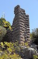
In the valley below the castle hill, rock graves have been dug into the southern wall of the valley, which are now used as storage rooms. Remains of a columned altar with bust reliefs are preserved in the valley, there are also remains of a tomb in polygonal masonry with an inscription. Serra Durugönül , who visited the fortress in the mid-1990s, reports on the remains of a statue of a woman and a lion. On the summit of the castle hill, which overlooks the Şeytan Deresi, an 83 × 45 meter living area with numerous water reservoirs is walled. The walls are made of little hewn polygonal stones. This is followed by a walled courtyard with the entrance in the northwest, here the walls have been smoothed. An inscription on the lintel of the entrance is no longer legible. From there, further walls with heights between six and seven meters made of embossed polygonal blocks run down into the valley. In several places they form apparent towers, i.e. wall squares, which from a distance give the impression of towers. On a stone that fell from this wall is a badly legible inscription, from which it can be seen that the castle was built at the time of an eponymous official. According to the shape of the letters, the inscription goes back to the 3rd or 2nd century BC. Dated. Below the lower tower at the foot of the mountain is a niche with a warrior relief.
Research history
The first exploration of Mancınıkkale was carried out by Levent Zoroğlu in 1987, soon afterwards Friedrich Hild and Hansgerd Hellenkemper visited the place as part of their trips to the Cilicia, and finally Serra Durugönül described the castle complex in 1995/96.

Column altar with bust reliefs

Lower acropolis wall (tower) with cistern
Sight tower
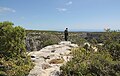
Upper plateau with a view of the Şeytan Deresi

Warrior relief


literature
- Friedrich Hild, Hansgerd Hellenkemper: Kilikien and Isaurien. Tabula Imperii Byzantini Volume 5. Verlag der Österreichischen Akademie der Wissenschaften, Vienna 1990 p. 340 ISBN 3-7001-1811-2 .
- Serra Durugönül: towers and settlements in the Rough Cilicia. Asia Minor Studies Volume 28. Rudolf Habelt, Bonn 1998 pp. 50–52, T. 26–27, ISBN 3-7749-2840-1 .