
Keşlitürkmenli
| Keşlitürkmenli | ||||
|
||||
| Basic data | ||||
|---|---|---|---|---|
| Province (il) : | Mersin | |||
| District ( ilçe ) : | Silifke | |||
| Coordinates : | 36 ° 31 ' N , 33 ° 58' E | |||
| Height : | 846 m | |||
| Residents : | 241 (2012) | |||
| Telephone code : | (+90) 324 | |||
| Postal code : | 33940 | |||
| License plate : | 33 | |||
| Structure and administration (as of 2016) | ||||
| Muhtar : | Rasim Dölek | |||


Keşlitürkmenli is a place in the district of Silifke in the Turkish province of Mersin . Until 2012 Keşlitürkmenli was a village with 241 inhabitants at last and then became part of the district town of Silifke after a regional reform . In the modern place, which only emerged in the 20th century as a street village at a fork in the road, there are remains of an ancient settlement and a Roman villa.
location
Keşlitürkmenli is located about ten kilometers north of the district town of Silifke and 65 kilometers southwest of the provincial capital Mersin . It is on the road from Atakent , the ancient Korasion , via İmamlı to Uzuncaburç , the ancient Olba . You pass the ruins of the ancient places Karadedeli, Karakabaklı and Işıkkale , Kültesir and Meydankale. In Keşlitürkmenli a road branches off to the east, which leads to Cambazlı , Sömek , Esenpınar and finally to Limonlu , the ancient Lamos. The Roman - Early Byzantine villa rustica Gökkale is about 2.5 kilometers southwest of the village .
Settlement remains
In the east of the town center, on a limestone hill south of the road to Cambazlı, are the remains of a village settlement from the Roman - Early Byzantine period ( location ). Remnants of walls, lintels and pillars as well as belt arches can be seen in around 30 houses . A house in polygonal masonry on the summit of the summit appears to be the oldest, other younger imperial buildings are closely staggered below. Numerous cisterns belong to the houses. On the western slope of the hill, sparse remains of a three-aisled basilica have been preserved. The apse is carved into the rock, as are two small flanking side apses, only the upper part is made of limestone blocks. They are now used as a farm storage room. Nothing has been preserved from the masonry parts of the naos and the division of the naves . The German archaeologists Friedrich Hild and Hansgerd Hellenkemper , who visited the site in the 1980s, were able to observe the Naostür in situ and report on the access to a vault under the church on its north side.

Apses of the basilica

Building front
Lintel, belt arch, graves

Room carved into the rock


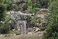
Villa rustica
About 600 meters southwest of the settlement hill, west of the road coming from Korasion, are the remains of a building complex on a limestone knoll ( location ). The widely visible location, structure and dimensions of 30 × 40 meters correspond to the type of a Roman villa rustica . To the east, facing the street, is the rectangular mansion. It had at least two floors. Behind it is a large courtyard, the pavement of which can still be seen clearly. It was surrounded by other rectangular parts of the building. A cistern and a pressing plant, presumably for oil, belonged to the courtyard. The complex has different masonry techniques, small-scale polygonal masonry as well as isodomous stone sections with different stone sizes. This suggests several construction phases. The first construction is dated to the early imperial period, the use lasted until the early Byzantine period. Hild and Hellenkemper report that the ruin was repaired and rebuilt again in the 20th century and was in use again for several decades.

Villa from the east

Front of the mansion, oil press

Paved courtyard from the west


literature
- Hansgerd Hellenkemper, Friedrich Hild: New research in Kilikien. Publications of the commission for the Tabula Imperii Byzantini Volume 4. Verlag der Österreichischen Akademie der Wissenschaften, Vienna 1986, ISBN 3-7001-0771-4 , p. 62 fig. 61–64.
- Friedrich Hild, Hansgerd Hellenkemper : Kilikien and Isaurien. Tabula Imperii Byzantini Volume 5. Publishing house of the Austrian Academy of Sciences, Vienna 1990, ISBN 3-7001-1811-2 , pp. 299-300.
- Ümit Aydınoğlu: The Farms in Rough Cilicia in the Roman and Early Byzantine Periods In: Adalya XIII 2010 pp. 248–249, 278–279.
Web links
Individual evidence
- ↑ Turkish Institute for Statistics ( Memento from November 2, 2014 in the Internet Archive )
- ^ Website Silifke