Marigot (Dominica)
| Marigot | ||
|---|---|---|
|
|
||
| Coordinates | 15 ° 32 ′ N , 61 ° 17 ′ W | |
| Basic data | ||
| Country | Dominica | |
| Saint Andrew | ||
| ISO 3166-2 | DM-02 | |
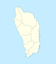
Marigot ( French swamp ) is the largest place in the Parish Saint Andrew in northeast Dominica . In 2001 the village had 2676 inhabitants.
geography
The place is located on a promontory ( Pointe Augustine ) on the northeast coast between the towns of Wesley and Dominica . The Dr Nicholas Liverpool Highway connects the places. To the north is Londonderry Bay . The village is nestled between the bays of Mango Hole Bay in the northeast with its foothills of Marigot Bay , Middle Bay and Panto Hole Bay , as well as Pagua Bay in the south near Atkinson . There is a library and the Marigot Hospital . The fishing port "Marigot Port and Fisheries Complex" is located on Marigot Bay , and directly north of it is the main airport on the island, Douglas-Charles Airport (Melville Hall Airport until 2014). To the south of the village, the Morne Concorde rises to 681 m above sea level .

Waters
Numerous streams run from the island's interior to the sea, including: Melville Hall River (Kachibona River) with its tributary Kanal River , Crébiche (Mantipo) River , New Castle Gutter , Geoffrey Gutter and Marechal River .
religion
There is the Marigot Methodist Church , the Marigot SDA Church , and the prayer house of the Marigot Congregation of Jehova's Witnesses .
Personalities
- Edison James (born 1943), Prime Minister
- Billy Doctrove , cricket umpire (umpire)
Individual evidence
- ↑ Commonwealth of Dominica: Population and Housing Census 2001: Roseau, Dominica, Central Statistical Office, Ministry of Finance and Planning.
