
Mariner glacier
| Mariner glacier | ||
|---|---|---|
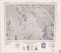
 Tongue of Mariner and Borchgrevink Glaciers , 1967 map |
||
| location | Victoria Land , East Antarctica | |
| Mountains | Transantarctic Mountains | |
| length | 100 km | |
| Coordinates | 73 ° 15 ′ S , 167 ° 30 ′ E | |
|
||
| drainage | Lady Newnes Bay | |

The Mariner Glacier is a large, approximately 100 km long glacier in East Antarctica, Victoria Land . It flows from the polar plateau between the Mountaineer Range and the Malta Plateau and flows in the form of a floating glacier tongue at 73 ° 27 ' S , 168 ° 20' E into Lady Newnes Bay on the Borchgrevink coast .
Captain John Cadwalader of the United States Navy explored the lower section of the glacier on a flight from the icebreakers USS Glacier and USS Staten Island , the south, together with two participants in a campaign carried out from 1958 to 1959 as part of the New Zealand Geological Survey Antarctic Expedition the Coulman island anchored. Is named glaciers in honor of the sailors ( English mariner ), involved in the discovery and exploration of Antarctica were involved.
Web links
- Mariner Glacier in the Geographic Names Information System of the United States Geological Survey (English)
- Mariner Glacier on geographic.org (English)
Individual evidence
- ↑ Mariner Glacier Tongue on geographic.org (English). Retrieved December 9, 2015.
upper part in the southeast of the map

middle part in the southwest of the map

