Maseltrangen
| Maseltrangen | ||
|---|---|---|
| State : |
|
|
| Canton : |
|
|
| Constituency : | Sea gaster | |
| Political community : | Schänis | |
| Postal code : | 8723 | |
| Coordinates : | 722 050 / 227813 | |
| Height : | 437 m above sea level M. | |
| Residents: | 400 | |
|
Maseltrangen |
||
| map | ||
|
|
||

Historical aerial photo from 200 m by Walter Mittelholzer from 1919
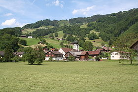
Maseltrangen is a scattered settlement in the political municipality of Schänis in the Swiss canton of St. Gallen . Maseltrangen is on the main road between Schänis and Kaltbrunn and is served by the Ziegelbrücke - Uznach post bus line.
The small village at 437 m above sea level. M. is on the eastern edge of the Linth Plain . Important branches of business are agriculture, restoration and small businesses. In Maseltrangen flowing Maseltrangerbach from the Front and Rear Maseltrangerbach together. To the northwest of the scattered settlement lies the Gasterholz, an elevation of a maximum of 552 m above sea level. M. Around 400 people live in Maseltrangen.
Web links
Commons : Maseltrangen - Collection of images, videos and audio files
Individual evidence
- ↑ community Schänis Online: outside villages. In: schaenis.ch. Retrieved April 8, 2014 .


