
Masuleh
| Masuleh | |||
|---|---|---|---|
 |
|||
|
|||
| Basic data | |||
| Country: |
|
||
| Province : | Gilan | ||
| Coordinates : | 37 ° 9 ′ N , 48 ° 59 ′ E | ||
| Height : | 1050 m | ||
| Residents : | 564 (2012) | ||
| Time zone : | UTC +3: 30 | ||
| Website: | www.masooleh.ir | ||

Masuleh ( Persian ماسوله) is a village in the Iranian province of Gilan near the southern shore of the Caspian Sea . Masuleh was in the UNESCO as a World Heritage proposed.
According to an extrapolation of 2012, Masuleh has 564 inhabitants and is located at an altitude of 1050 m on the northern slope of the Elburs Mountains . It is located about 60 km southwest of Rasht and about 20 km south of Fuman .
The village is built in terraces into the very steep slope. Because of the gradient, there are only a few streets between the houses, instead almost exclusively steps and small serpentine alleys.
The houses are usually two-story and built close together. Mud bricks, which are covered with an ocher-colored clay plaster, are primarily used as building material. The roofs are usually flat or only slightly inclined and often serve as footpaths for the next building level above. Masuleh is characterized by beautifully designed oriels, doors and windows made of wood carving. Due to the unusual architecture of the houses, the place is a tourist attraction.
photos

Masuleh, overview of the town (westward direction)

Masuleh, detail
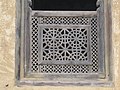
Window in Masuleh

Tourist attraction, Masuleh

Cloud forests of Gilan, surroundings of Masuleh


Web links
- Official site (English or Persian)
Individual evidence
- ↑ Archived copy ( Memento of the original dated December 29, 2011 in the Internet Archive ) Info: The archive link was automatically inserted and not yet checked. Please check the original and archive link according to the instructions and then remove this notice.