Matachel (Guadiana)
| Río Matachel | ||
|
Bridge below the Alange dam |
||
| Data | ||
| location | Spain , Extremadura | |
| River system | Guadiana | |
| Drain over | Guadiana → Atlantic Ocean | |
| source |
Sierra Morena 38 ° 18 ′ 24 " N , 5 ° 44 ′ 3" W. |
|
| Source height | approx. 583 m | |
| muzzle | Guadiana Coordinates: 38 ° 50 ′ 2 " N , 6 ° 16 ′ 38" W 38 ° 50 ′ 2 " N , 6 ° 16 ′ 38" W. |
|
| Mouth height | approx. 214 m | |
| Height difference | approx. 369 m | |
| Bottom slope | approx. 3 ‰ | |
| length | approx. 124 km | |
| Catchment area | 2546 km² | |
| Reservoirs flowed through | Dam Molinos de Matachel , dam Alange | |
|
Guadiana river system |
||
|
Tributaries of the Guadiana (the Matachel is number 8) |
||
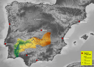
The Río Matachel is an approx. 124 km long left (southern) tributary of the Río Guadiana , which flows through the province of Badajoz in the autonomous community of Extremadura in southern Spain .
course
The source of the Río Matachel is located on the north side of the Sierra Morena approx. 12 km southeast of the village of Maguilla . About 4 km west of the village of Hornachos , the Matachel is dammed by the Molinos de Matachel dam to form a reservoir ( Embalse de los Molinos de Matachel ). The Matachel finally flows into the Río Guadiana about 10 km southeast of the city of Mérida south of the village of Don Álvaro . About 4 km before its confluence with the Guadiana it is dammed up by the Alange dam to form a four times larger reservoir ( Embalse de Alange ).
Tributaries
Numerous streams (arroyos) flow into the Río Matachel; nevertheless, the river falls almost dry in summers with little rain.
Communities
Seven municipalities, the main towns of which are not directly on the river bank, joined forces in 2006 to form the municipal association ( mancomunidad ) Tierra de Barros-Río Matachel to coordinate their economic and tourist interests .
Web links
- Newspaper article on Río Matachel (Spanish)


