Mbomou
| Mbomou | ||
|
Catchment area of the Ubangi with the Mbomou (middle right) |
||
| Data | ||
| location |
|
|
| River system | Congo | |
| Drain over | Ubangi → Congo → Atlantic | |
| Headwaters | Central African Republic on the border with South Sudan 5 ° 1 ′ 30 ″ N , 27 ° 26 ′ 31 ″ E |
|
| Source height | 725 m | |
| muzzle | In the border area between the Democratic Republic of the Congo and the Central African Republic in the Ubangi coordinates: 4 ° 7 ′ 35 " N , 22 ° 25 ′ 55" E, 4 ° 7 ′ 35 " N , 22 ° 25 ′ 55" E |
|
| Mouth height | 395 m | |
| Height difference | 330 m | |
| Bottom slope | 0.34 ‰ | |
| length | 966 km | |
| Catchment area | 156,950 km² | |
| Discharge at the Bangassou A Eo gauge : 115,000 km² Location: 100 km above the mouth |
MNQ 1986–1988 MQ 1986–1988 Mq 1986–1988 MHQ 1986–1988 |
233 m³ / s 823 m³ / s 7.2 l / (s km²) 1993 m³ / s |
| Discharge at the mouth A Eo : 156,950 km² at the mouth |
MQ 1952–1974 Mq 1952–1974 |
1130 m³ / s 7.2 l / (s km²) |
| Left tributaries | Bili | |
| Right tributaries | Mbari ; Chinko ; Ouara | |
| Medium-sized cities | Bangassou | |
|
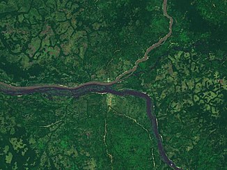
Satellite image of the confluence of the Uelle (from below) and Mbomou (from above) |
||
The Mbomou (sometimes called Bomu ) is a river in central Africa .
course
The river has its source on the border with South Sudan, about 5 km south of the city of Ezo . It unites with the Uelle at Yakoma and from the confluence forms the Ubangi , the second largest tributary of the Congo . The Mbomou forms the state border between the Central African Republic and the Democratic Republic of the Congo .
discovery
The Greek explorer Panagiotes Potagos explored the area on his second trip. He is said to have been the first European to discover the river in 1877.
Hydrometry
Average monthly flow of the Mbomou measured at the hydrological station in Bangassou, about 100 km above the confluence with the Uelle in m³ / s (mean value from 2 years 1986–1988).

Individual evidence
- ↑ a b J. Callede, Y. Boulvert, JP. Thiebaux: Le bassin de l'Oubangui, chap. 1
- ↑ a b The Mbomou at Bangassou ( page no longer available , search in web archives ) Info: The link was automatically marked as defective. Please check the link according to the instructions and then remove this notice.
- ↑ J. Callede, Y. Boulvert, JP. Thiebaux: Le bassin de l'Oubangui, chap. 4th
- ^ Extract from the Encyclopædia Britannica

