
Melekeok (city)
| Melekeok | |||
|---|---|---|---|
|
|||
| Coordinates | 7 ° 29 '36 " N , 134 ° 38' 3" E | ||
| Symbols | |||
|
|||
| Basic data | |||
| Country | Palau | ||
| Melekeok | |||
| ISO 3166-2 | PW-212 | ||
| surface | 28 km² | ||
| Residents | 299 (2012) | ||
| density | 10.7 Ew. / km² | ||


Melekeok is a place in the Pacific island republic of Palau . It is located in the Melekeok administrative region of the same name on Babeldaob , the largest island in Palau. With 299 inhabitants (as of 2012), the entire administrative area has a village character. However, there are no larger settlements on the entire main island.
Individual houses in Melekeok are still partially covered by the rainforest. While the buildings of very different quality - from shabby dwellings to American-style villas - are almost at sea level along the main road near the coast, an extensive complex of government buildings was built in 2006 in Palau's capital Ngerulmud, two kilometers southwest of the settlement. The representative buildings include a parliament and buildings for the executive and judiciary. The so-called Capitol complex is located high up in a quiet green area and is visible far over the island.
history
The Melekeok area has a long history as a center of power in Palau. It was often the scene of village wars. There were several men's houses (Bais) that were destroyed during the Japanese occupation . In 1992 a men's house was rebuilt in the traditional style.

Flag of Melekeok
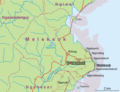
Topographic map of Melekeok

Beach at Melekeok


Web links
Individual evidence
- ↑ 2013 Statistical Yearbook. Bureau of Budget and Planning, Ministry of Finance, Republic of Palau, p. 3. Retrieved January 24, 2017.