
Mendocino National Forest
|
Mendocino National Forest
IUCN Category VI - Protected Area with Sustainable use of Natural Resources |
||
 View of Howard Lake |
||
| location | California , USA | |
| surface | 3,696 km² | |
| Geographical location | 39 ° 34 ' N , 122 ° 49' W | |
|
||
| Setup date | February 6, 1907 | |
| administration |
US Forest Service , US Department of Agriculture |
|
_relief_location_map.png)
The Mendocino National Forest is located in northwest California in the California Coast Mountains and covers an area of approximately 3,700 km². Like all national forests, it is federally owned and is used intensively for forestry .
The Mendocino National Forest is the only National Forest in California that does not have a main paved road. There are various leisure and recreational opportunities within the forest area. There are many hiking and camping opportunities. Also paragliding and fishing is possible. Various water sports are also permitted on the area's largest lake, Lake Pillsbury . It borders directly on the Berryessa Snow Mountain National Monument in the southeast .
Flora and fauna
The sanctuary is home to the largest California population of Tule elk . The animals were almost extinct in the 18th century and reintroduced to the park by the California Department of Fish and Wildlife . Today the population is stable and can be hunted ten days a year. In addition to the Mendocino National Forest, the animals only occur in the Los Padres National Forest . Other large mammals in the park include black bears , pumas and bobcats .
The landforms of the area are diverse. In addition to oak and conifer forests , there are also chaparral and savanna areas , as well as wet meadows. The plants of the ecosystem include the California poppy , common lilac and beard thread .
Wilderness Areas
The Mendocino National Forest includes four total reserves that are designated as Wilderness Area :
history
In the 18th century, the National Forest area was mined and lumbered. It was hoped to find larger copper deposits there, but this did not happen. The first healing springs were established as early as the early 19th century and are still used today.
On February 6, 1907, President Theodore Roosevelt designated the area as Stony Creek National Forest . At that time, the area was much larger in area than today's National Forest. As early as 1908 it became apparent that such a large forest area was difficult to manage and so the Stony Creek National Forest was divided into the California National Forest and the Trinity National Forest . To avoid confusion of names, President Herbert Hoover renamed the area to its current name, Mendocino National Forest, in 1932.
On July 10, 1953, 15 firefighters were killed in the Rattlesnake forest fire in the Mendocino National Forest . While trying to create a firebreak, they were overrun by the fire and burned.
photos

View of the Sanhedrin Mountains

Hot spring in the reserve
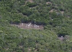
Memorial crosses for the victims of the Rattlesnake forest fire

Map of the park


Web links
See also
Individual evidence
- ↑ "Land Areas of the National Forest (English; PDF 2.82 MB), at www.fs.fed.us in January 2012, accessed on June 7, 2017
- ↑ a b c "Information about the park and its history" (English), accessed on June 8, 2017
- ^ "Information on leisure and recreation offers" , accessed on June 8, 2017
- ↑ "Information about the Tule-Wapiti" , accessed on June 8, 2017
- ^ Charles J. Gleeson: "The Man Who Played WIth Fire" (English; PDF , 1.03 MB), at www.foresthistory.org, accessed on May 12, 2017