Mfimi (Kwa)
|
Mfimi Fimi |
||
|
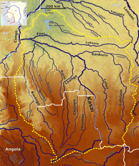
The Fimi in the catchment area of the Kasai (top left) |
||
| Data | ||
| location |
|
|
| River system | Kasai | |
| Drain over | Kasai → Congo → Atlantic | |
| source | Outflow from Lake Mai Ndombe | |
| Source height | about 290 m | |
| muzzle | at Mushie in the Kasai coordinates: 3 ° 1 ′ 40 ″ S , 16 ° 55 ′ 20 ″ E 3 ° 1 ′ 40 ″ S , 16 ° 55 ′ 20 ″ E |
|
| Mouth height | 284 m | |
| Height difference | about 6 m | |
| Bottom slope | about 0.04 ‰ | |
| length | 164 km | |
| Catchment area | 140,500 km² | |
| Left tributaries | Lukenie | |
The Mfimi (or Fimi ) is a short river in the west of the Democratic Republic of the Congo . With its longest tributary, it has a length of about 1000 km.
course
The river has its source in the Mai Ndombe Lake . Due to its shape and the changing water levels in Lake Mai Ndombe, a source is difficult to identify. Immediately after leaving the lake, across from Kutu , the hatch opens from the left . After 164 km the Fimi flows into the Kasai at Mushie , which is called Kwa from then on.
ID
Depending on the source, the Fimi is named as a continuation of the Lukenie from the mouth of the Mai-Ndombe Lake, or the Lukenie as a tributary of the Fimi. The two rivers are sometimes combined as the Lukenie-Fimi.
