Miles glacier
| Miles glacier | ||
|---|---|---|
|
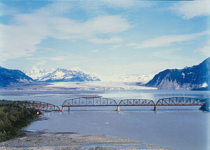
Miles Glacier Bridge in the foreground, behind the glacier tongue of the Miles Glacier (1984) |
||
| location | Alaska ( USA ) | |
| Mountains | Chugach Mountains | |
| Type | Valley glacier | |
| length | 50 km | |
| Exposure | west | |
| Altitude range | 2000 m - | |
| width | ⌀ 3.6 km | |
| Coordinates | 60 ° 40 ′ N , 144 ° 29 ′ W | |
|
|
||
| drainage | Copper River | |
The Miles Glacier is a glacier in the US state of Alaska . It is located in the Chugach National Forest 70 km east-northeast of Cordova .
geography
The 2000 m high nutrient area of the Miles Glacier is located in the Chugach Mountains north of Mount Tom White . The Miles Glacier flows west for 50 km and ends on the east bank of the Copper River at the level of the Miles Glacier Bridge , also known as the Million Dollar Bridge , at the east end of the Copper River Highway . The mean glacier width is 3.6 km. On its northern flank is Van Cleve Lake , a glacial edge lake below the Van Cleve Glacier . The Copper River shows a widening at the glacier tongue of the Miles Glacier, the so-called Miles Lake .
Naming
The glacier was named by Lieutenant Allen during his Alaska expedition in 1885 after Major General Nelson A. Miles (1839-1925).

